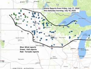
Storm Reports from around the Northland from Friday night-Saturday morning, July 17-18, 2020
Source: https://www.weather.gov/
2:51 AM 7/18: Thunderstorm Wind Gust 63 mph. 1 W Sanborn, WI (Bayfield County)
2:10 AM 7/18: Thunderstorm Wind Damage. 3 SSW Trego, WI (Washburn County) On the north side of Spooner Lake. One boat lift flipped. Multiple boat lifts shifted and boat lift covers ripped. A window broken from a flying 40 pound piece of dock.
1:48 AM 7/18: Thunderstorm Wind Damage. 2 N Blueberry, WI (Douglas County) Trees and power pole guy wires down at County road O and Lindgren road. *Possible tornado damage*
1:35 AM 7/18: Thunderstorm Wind Damage. 2 NE Grantsburg, WI (Burnett County) Small section of roof torn off of hangar at the Grantsburg Airport.
11:00 PM 7/17: Thunderstorm Wind Damage. Palisade, MN (Aitkin County) Small portion of barn roof torn off.
10:00 PM 7/17: Thunderstorm Wind Damage. Pontoria, MN (Cass County) Multiple trees down in central parts of the county.
9:55 PM 7/17: Thunderstorm Wind Gust 62 mph. 5 E Inguadona, MN (Cass County)
9:43 PM 7/17: Thunderstorm Wind Damage. 2 W Jenkins, MN (Cass County) Branches of 1.5-2 inches in diameter downed.
9:34 PM 7/17: Thunderstorm Wind Gust 47 mph. 4 E Jenkins, MN (Crow Wing County)
9:29 PM 7/17: Thunderstorm Wind Damage. 5 N Pontoria, MN (Cass County) Several trees 10-12 inches in diameter snapped or blown down.
8:52 PM 7/17: Thunderstorm Wind Damage. Hackensack, MN (Cass County) Power lines down per county dispatch.
8:40 PM 7/17: Thunderstorm Wind Gust 60 mph. Whipholt, MN (Cass County)
Note: Last night’s severe weather event really didn’t pan out as expected, but this isn’t necessarily a bad thing! Some parts of the Northland did have wind damage from the storms last night, and there may even have been a tornado early this morning east of Superior, around the Blueberry, Wisconsin area in northeast Douglas County, but for the most part the Northland dodged a bullet given the ingredients that were in place last night, certainly could have been a higher impact severe weather/wind event.
The good news with the storms from last night and early this morning is that we got more rain!

Rainfall Reports from around the Northland from Friday night, July 17, 2020 thru Saturday morning, July 18, 2020.
Source: https://www.weather.gov/dlh/; https://mesowest.utah.edu/
3 E Brainerd, MN: 5.00″
Garrison, MN: 4.00″
Sturgeon Lake, MN: 4.00″
Whipholt, MN: 4.00″
3 SW Cohasset, MN: 3.63″
4 S Bruno, MN: 3.50″
East Gull Lake, MN: 3.30″
Brainerd, MN: 3.29″
Finlayson, MN: 2.80″
Willow River, MN: 2.75″
Iron River, WI: 2.50″
Superior, WI: 2.50″
Moose Lake, MN: 2.36″
Hill City, MN: 2.24″
Holyoke, MN: 2.00″
Cotton, MN: 1.92″
1.2 W Solon Springs, WI: 1.88″
3 SW Carlton, MN: 1.85″
1 E Proctor, MN: 1.80″
Lester Park, MN: 1.70″
Floodwood, MN: 1.63″
Walker, MN: 1.44″
Two Harbors, MN: 1.42″
Cloquet, MN: 1.17″
3 E Wright, MN: 1.13″
Duluth Airport: 1.05″
Cass Lake, MN: 1.03″
Bigfork, MN: 1.00″
Siren, WI: 0.90″
Ashland, WI: 0.81″
Silver Bay, MN: 0.78″
Cook, MN: 0.75″
Isabella, MN: 0.72″
Winter, WI: 0.67″
4 W Clam Lake, WI: 0.65″
Hayward, WI: 0.60″
Hibbing, MN: 0.55″
Thanks for reading!
Tim
Leave a Reply