It’s been a while since we’ve had a day that was this cool and rainy across the Northland, and just think a few months from now a system like today’s would bring significant snow and wind to the Northland, but I digress.
-Scattered showers and thunderstorms with downpours, funnel clouds, frequent lightning, and possibly some gusty winds and hail will move across portions of northwest Wisconsin this evening, otherwise the rest of the area can expect some drizzle or light rain at times into this evening, but the potential for heavier rain has ended outside of northwest Wisconsin.
-Some sun should return to northeast Minnesota and northwest Wisconsin on Wednesday, although cloud cover may have a tough time breaking most of the day over the Arrowhead and near Lake Superior. Highs Wednesday will be in the 60s and 70s.
-Temperatures will warm up and humidity levels will ramp up Friday through the weekend. Looks like will have highs in the 80s over most of the Northland Friday, Saturday and Sunday, while dew points climb back into the muggy mid 60s to mid 70s. Note: Temperatures may end up a little warmer or cooler Friday through Sunday depending on cloud cover and whether or not we see some thunderstorm activity and also on the timing of any thunderstorms.
Rainfall Reports from around the Northland from Tuesday, July 21, 2020
Note: Rain totals below through 3 PM Tuesday, July 21, 2020.
Source: https://mesowest.utah.edu/
12 N Grand Rapids, MN: 1.70″
Walker, MN: 1.60″
Solon Springs, WI: 1.60″
Minong, WI: 1.55″
7 SE Grand Rapids, MN: 1.54″
5 SSE South Range, WI: 1.35″
Chisholm-Hibbing Airport: 1.23″
3 E Wrenshall, MN: 1.10″
Hill City, MN: 1.08″
Saginaw, MN: 1.07″
Cloquet, MN: 1.04″
Superior Airport: 1.04″
Cass Lake, MN: 1.00″
Hinckley, MN: 0.96″
Moose Lake, MN: 0.90″
Ely, MN: 0.90″
Clam Lake, WI: 0.89″
Siren, WI: 0.84″
Bigfork, MN: 0.77″
Duluth Airport: 0.75″
Ashland, WI: 0.75″
Eveleth-Virginia, MN: 0.73″
McGregor, MN: 0.72″
Littlefork, MN: 0.68″
Glidden, WI: 0.68″
Aitkin, MN: 0.65″
Brainerd, MN: 0.55″
Two Harbors, MN: 0.48″
International Falls, MN: 0.48″
Hayward, WI: 0.46″
Orr, MN: 0.42″
Washburn, WI: 0.41″
Isabella, MN: 0.20″
Grand Marais Airport: 0.18″
A look at radar estimated rainfall totals from today’s event zoomed in on the Twin Ports.

A zoomed out view of radar estimated rainfall totals across the Northland from today, Tuesday, July 21, 2020.

A look at today’s system impacting the Northland per Goes-16 water vapor loop from Tuesday, July 21, 2020 – Loop time 11:06 AM to 3:36 PM CDT.
Source: https://weather.cod.edu/

Radar loop from Tuesday, July 21, 2020 – Loop time 9:00 AM to 3:45 PM CDT.

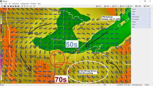
Pattern for late this week into the weekend still looks like it will feature strong ridging across the Midwest while a trough heads into the Northern Rockies. This type of pattern should be a warm and humid one for the Northland, and some thunderstorms (orange outlined area on map) are possible as well to the north of the hottest air which should remain south of our area. Note: It looks like will see the ridge break down and shift back toward the south early to mid next week resulting in cooler and less humid weather for the upper Midwest.
Source: https://www.wpc.ncep.noaa.gov/

Thanks for reading!
Tim
Leave a Reply