The weather can’t get much nicer than this, and the rest of this week looks just as nice as it was today (Monday) This could very well be the nicest week of summer 2020 when you factor in the combination of no rain (for most) low humidity, some sun and the mild temperatures, enjoy!
Note: Our next chance for rain in Duluth won’t be until Saturday, and those chances don’t look very good at the moment, so it appears we’re going right back into a dry pattern which has been a common theme here in 2020! Over 5.00″ below normal precipitation in Duluth since January 1st, and this number will be climbing this week.
Today marks the 19th day so far this month with a high temperature of at least 80 degrees at Duluth, Minnesota. July 2020 is currently tied for 5th place with July 2011, July 1989 and July 1916 for the most number of 80 degree days for the month of July.
Note: The record for most number of 80 degree or warmer days in Duluth for July is 25 days set in 2012. We won’t be breaking this record this July as it looks like we may only get 1 or 2 more 80 degree days in Duluth for the rest of this month, so it looks like July 2020 will rank 4th or stay at 5th place for most number of 80 degree days.
Rainfall Reports from Monday, July 27, 2020
Source: https://mesowest.utah.edu/
Two Harbors, MN: 0.13″
Grand Marais Airport: 0.12″
Cook, MN: 0.08″
Silver Bay, MN: 0.07″
Ely, MN: 0.02″
Scattered rains today roughly north/east of a line from Bigfork to Two Harbors to Ashland to Hurley, anywhere south of that line it was dry today.

Looks like we could see a few showers pop-up again Tuesday afternoon over far northeast Minnesota and far northern Wisconsin, but instability looks lower on Tuesday so this should limit the thunder potential.
It looks like will stay dry again in Duluth and Superior on Tuesday.
Highs on Tuesday will be in the 70s to around 80 degrees in northeast Minnesota and northwest Wisconsin with northwest winds 5 to 15 mph with gusts to 25 mph.
18z NAM 3km model simulated radar forecast valid from 7 PM Monday to 7 PM Tuesday.
Source: https://weathermodels.com/

Goes-16 water vapor loop from Monday, July 27, 2020 showing a spin across Ontario Canada, that is an upper level low which will move slowly ESE over the next few days.
Loop time ~9 AM to ~5 PM.
Source: https://weather.cod.edu/

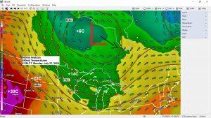
Warm air near the surface combined with some colder air aloft made the atmosphere a bit unstable across the Northland today, this coupled with an upper level low over Ontario province led to the development of scattered showers and thunderstorms this afternoon mainly over northeast Minnesota. Brief downpours, lightning and gusty winds have been the main hazards with the storms today, but there was one report of small hail 0.25″ diameter near Grand Marais at 5:15 PM today.
Scattered showers and storms will continue to move southeast across northeast Minnesota, western Lake Superior and extreme northern Wisconsin into early this evening before ending overnight. Note: Should stay dry tonight in Duluth and Superior.
Radar loop 12 PM to 5:35 PM, Monday, July 27, 2020.
Source: https://weather.cod.edu/

Thanks for reading!
Tim
Leave a Reply