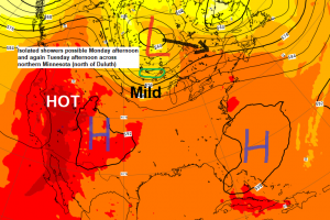
Looks like the final week of July will be a dry one across most of the Northland, but there could be a few isolated showers that pop-up during the afternoon and evening on Monday and Tuesday, but these shouldn’t amount to much where they occur, and the majority of these should remain north of Duluth and Superior.
Note: 5.25″ of rain has fallen so far this month in Duluth, and July 2020 will finish above normal in the rainfall department even if we don’t get anymore rain this month, but our precip deficit since January 1st will be climbing this week, or unless we get some rain, by the way we’re still nearly -5.00″ below normal for precipitation in Duluth since January 1st.
Source: 12z European ensemble model 7.26.2020; https://weathermodels.com/

18z NAM 3km model simulated radar forecast valid from 7 AM Monday to 7 PM Monday.
Source: https://weathermodels.com/

A mid to upper level low will move slowly ESE out of Ontario province from Monday to Wednesday, this will put the Northland in a NW flow aloft which will lead to a much more comfortable air mass across the Northland over the next few days. High temperatures on Monday and Tuesday are forecast to be in the 70s to around 80 degrees, right about normal for late July. It’ll be a touch breezy at times on Monday as northwest winds gust to around 20-25 mph.
Local Storm Reports from Saturday through Sunday morning, July 25-26, 2020.
Source: https://www.weather.gov/dlh/
10:20 AM 7/26: Radisson, WI (Sawyer County) Flash Flood – Water was over portions of County Road H near the village of Radisson.
10:00 AM 7/26: 6 miles SW Butternut, WI (Price County) Heavy Rain 5.81″. Observer reported several streams over roads
8:12 AM 7/26: Couderay, WI (Sawyer County) Flash Flood – Water was over one of the lanes of Highway 70/27 near the village of Couderay
8:00 AM 7/26: 1 mile SSW Duluth, MN (St. Louis County) Heavy Rain 1.50″.
5:30 AM 7/26: 1 mile SE Duluth, MN (St. Louis County) Heavy Rain 2.25″.
4:15 AM 7/25: 6 miles SSE Wilkinson, MN (Cass County) Many large trees down near Walker, MN.
Note: Some parts of Duluth had torrential downpours with those scattered storms Saturday evening, but the higher rainfall totals were quite localized as Hermantown, Proctor and Superior only saw between a tenth to quarter inch of rain Saturday evening per radar estimates.

Locations southeast of Hayward saw some heavy rain Sunday morning which led to some flooding. Radar estimates show anywhere from 2 to 4 inches of rain fell from Radisson to Loretta extending into far southern Ashland county around the Butternut area.

Torrential downpours and flash flooding last night into this morning across portions of south-central Minnesota. Those yellow colors on the image below indicate rainfall totals of 8 inches or more!
The highest rainfall totals last night into this morning were along the Minnesota River from Morton to Mankato and extending southeast to the Janesville and Waseca areas.

…Record Warm Low Temperatures set across the Northland on July 25, 2020…
Brainerd, Minnesota
New record warm low for 7/25: 77 degrees
Old record warm low for 7/25: 72 degrees set in 2007
Ashland, Wisconsin
New record warm low for 7/25: 73 degrees
Old record warm low for 7/25: 66 degrees set in 2012
Duluth, Minnesota
New record warm low for 7/25: 72 degrees
Old record warm low for 7/25: 69 degrees set in 1886
Note: International Falls, Minnesota tied their record warm low temp of 68 degrees on Saturday, July 25, 2020, this ties the record which was set on July 25, 1916.
A less humid air mass is on the move! It is taking a little while to get here, but a much less humid air mass will arrive in Duluth and Superior by this evening, and it looks like most of the week ahead will be quite comfortable in terms of the dew point which should mostly be in the 50s over the next few days.

Thanks for reading!
Tim
Leave a Reply