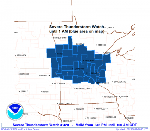
4:08 PM Friday – A Severe Thunderstorm Watch has been issued for portions of central Minnesota, southeast North Dakota, northeast South Dakota and northwest Wisconsin effective this Friday afternoon and Saturday morning from 3:45 PM until 1 AM.
Primary threats include
Scattered damaging wind gusts to 70 mph likely
Scattered large hail and isolated very large hail events to 2 inches in diameter possible
A tornado or two possible
This watch includes the following counties in east-central Minnesota – Cass, Crow Wing, Aitkin, Carlton and Pine, and in northwest Wisconsin – Douglas and Burnett.
Some cities in the Northland that are included in this watch are Walker, Cass Lake, Brainerd, Hill City, Aitkin, McGregor, Moose Lake, Hinckley, Sandstone, Solon Springs, Danbury, Grantsburg and Siren.
Remember a severe thunderstorm watch means conditions are favorable for severe thunderstorms in and close to the watch area. Persons in these areas should be on the lookout for threatening weather conditions and listen for later statements and possible warnings. Severe thunderstorms can and occasionally do produce tornadoes.
There is a chance for heavy rainfall tonight in portions of the Northland with southern areas having the greatest chance of picking up 1 to 3 inches or more of rain tonight, this would include the Brainerd lakes, Hinckley, and Hayward lakes areas, but could extend as far north as Duluth, Hill City, Grand Rapids, Hibbing and Ely.
Source: https://weathermodels.com/


18z NAM 3km model simulated radar forecast ending at 7 AM Saturday shows the possibility for one or two rounds of showers and thunderstorms impacting northeast Minnesota and northwest Wisconsin tonight into early Saturday morning.
Note: Showers and thunderstorms are possible in Duluth and Superior anytime after 7 or 8 PM tonight with rain chances continuing overnight before ending after daybreak.
Source: https://weathermodels.com/

We have a bit of a spin in the atmosphere which is moving east out of eastern North Dakota this afternoon, this feature will continue to move east tonight bringing some showers and thunderstorms to the Northland.
Loop time: 11:01 AM to 2:26 PM CDT, Friday, August 7, 2020.
Source: https://weather.cod.edu/

There’s that dip in the 500mb flow which I mentioned in Thursday’s post, this system is creating atmospheric lift as it moves east which will help produce showers and thunderstorms over the Northland tonight.
Source: https://www.spc.noaa.gov/

Plenty of moisture in place for thunderstorms tonight with PWAT or precipitable water of 1.20″ to 1.50″ across the Northland. Downpours are likely with any thunderstorm tonight.

An impressive elevated mixed layer covered the Western High Plains today with Friday afternoon temperatures of 95 to 100 degrees while dew points were as low as 15 to 30 degrees! Note: This elevated mixed layer won’t really be going anywhere through the weekend and is one of the ingredients behind why we could have some strong storms in parts of the Northland the next few days.

There’s a pool of very unstable high octane energy air sitting over the Northern Plains this afternoon, and some of this highly unstable air will advect ENE into central Minnesota tonight thanks in part to a strengthening 850mb jet of 30-40 knots coming out of the SSW.

Less humid conditions are expected by Saturday afternoon into Saturday night across northern Minnesota as dew points fall into the 50s, but it looks pretty humid farther south including for areas near Lake Superior, Twin Ports, and all of northwest Wisconsin Saturday into Saturday evening with dew points in the 65 to 75 degree range!
Source: 12z European model 8.7.2020; https://weathermodels.com/

On Saturday will see a cold front move slowly ESE out of north-central Minnesota with this boundary likely stalling out somewhere over central or southern Minnesota Saturday night. The atmosphere could become quite unstable near this front late Saturday afternoon into Saturday night with some showers and thunderstorms possibly developing Saturday evening or overnight from southern and central Minnesota into west-central Wisconsin, it looks like this activity (if anything develops) would remain south of northeast Minnesota and northwest Wisconsin Saturday night unless the front stalls out a little farther north than what the computer models are showing today. Looks warm on Saturday with highs in the upper 70s to middle 80s in northeast Minnesota and northwest Wisconsin, but if skies clear early enough then we could have temperatures up around 90 degrees Saturday afternoon over parts of eastern Minnesota and northern Wisconsin.
Thanks for reading!
Tim
Leave a Reply