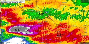
Strong thunderstorms producing vivid lightning and torrential rainfall impacted much of northeast and east-central Minnesota into northwest Wisconsin early Saturday morning with as much as 6 inches of rain reported in a corridor from Kettle River to Barnum south to Moose Lake.
Over 600 Lake Country Power members are without power in wake of early morning storms – Link to outage map http://outage.lcp.coop/#viewer-menu-parent
Storm Reports from around the Northland from Friday night and Saturday morning, August 7-8, 2020.
Source: https://www.weather.gov/dlh/
2:37 AM 8/8: Flash Flood. Kettle River, MN (Carlton County) Basement flooding reported along with power outages around the town of Kettle River.
12:40 AM 8/8: Marine Thunderstorm Wind 28 mph. 1 mile N of Port Wing, WI (Bayfield County)
12:15 AM 8/8: Marine Thunderstorm Wind 39 mph. 6 miles SE of Duluth, MN (St. Louis County) Measured at Duluth Sky Harbor Airport.
12:12 AM 8/8: Marine Thunderstorm Wind 34 mph. 1 ESE Duluth, MN (St. Louis County) Measured at Duluth Harbor.
10:43 PM 8/7: Hail 0.70 inch. 2 miles SSE Pine River, MN (Cass County)
10:35 PM 8/7: Non-Thunderstorm Wind Damage. 2 miles S of Emily, MN (Crow Wing County) Tree down across Highway 1.
8:54 PM 8/7: Hail 0.25 inch. 4 miles ENE Brevik, MN (Cass County) Gusty winds and heavy rainfall accompanied the pea size hail.
Rainfall Reports from around the Northland from Friday evening through early Saturday morning, August 7-8, 2020.
Source: https://www.weather.gov/dlh/
2 miles SSW Barnum, MN: 6.50″
2 miles ENE Kettle River, MN: 5.20″
Knife River, MN: 4.25″
8.1 miles W Solon Springs, WI: 3.34″
1 mile N Lake Nebagamon, MN: 3.00″
Holyoke, MN: 2.60″
6 miles SE La Prairie, MN: 2.38″
3 miles E Wright, MN: 2.23″
8 miles S Cohasset, MN: 2.15″
2 miles WSW Superior, WI: 2.10″
1 mile WSW Two Harbors, MN: 2.00″
Superior, WI: 1.80″
Gile, WI: 1.70″
3 miles N Hill City, MN: 1.70″
2 miles W Iron Junction, MN: 1.38″
Hayward, WI: 1.38″
Hibbing, MN: 1.31″
3 miles WNW Lester Park, MN: 1.30″
4 miles W Clam Lake, WI: 1.25″
Minong, WI: 1.20″
2 miles E Celina, MN: 1.15″
Lutsen, MN: 1.12″
Little Marais, MN: 1.10″
Ashland, WI: 1.09″
Cook, MN: 1.01″
Grand Marais, MN: 0.97″
Duluth Airport: 0.90″
3 miles E Orr, MN: 0.67″

Goes-16 satellite loop showing the cluster of strong storms which impacted much of the Northland Friday night and early Saturday morning.
Loop time from 11:01 PM Friday to 5:01 AM Saturday, August 7-8, 2020.
Source: https://weather.cod.edu/

Radar loop from 11 PM, Friday, August 7, 2020 to 5 AM, Saturday, August 8, 2020.

Thanks for reading!
Tim
Leave a Reply