A few rounds of strong to severe thunderstorms could affect portions of the Northland from late tonight through late Sunday evening.
A cold front will be stalling out tonight somewhere across central Minnesota into northern Wisconsin, this boundary will then lift NNE as a warm front on Sunday while we see another cold front move SE out of northwest Minnesota, and that boundary will move through northeast Minnesota and northwest Wisconsin Sunday night.
The atmosphere will remain quite unstable through Sunday evening, and with the different boundaries nearby, we should see some showers and thunderstorms develop at times tonight, Sunday and Sunday night. Unfortunately the computer models are struggling trying to figure out the timing and areas which will be impacted by these storms over the next 24-36 hours.
One scenario would have storms moving through parts of the Northland Sunday morning, then only a few showers Sunday night, while another scenario would have a few waves of storms impacting the Northland from Sunday morning through Sunday evening.
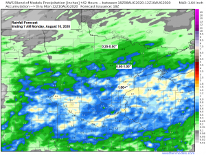
With the abundant moisture already in place the risk for torrential rainfall will continue where thunderstorms occur, and a few of the storms could also contain hail and gusty winds.
Stay Weather Aware!
18z NAM 3km model simulated radar forecast valid from 7 PM Saturday evening to 1 AM Monday morning.
Source: https://weathermodels.com/

18z HRRR model simulated radar forecast valid from 7 PM Saturday evening to 1 AM Monday.

Severe weather outlook for tonight
Marginal risk of severe thunderstorms in the dark green area while non-severe thunderstorms are possible in the lighter green shaded area.

There is a slight risk of severe thunderstorms on Sunday (yellow shaded area) roughly along and south of a line from Bigfork to Two Harbors to Bayfield, and a marginal risk of severe thunderstorms in the dark green shaded area.

A much drier air mass has moved into far northern Minnesota late this Saturday afternoon with dew points down into the 50s at International Falls, but a muggy air mass remains in place farther south with dew points around 70 degrees.
Expect some relief from the muggy air tonight mainly from the Iron Range north while it stays muggy farther south. Then on Sunday the entire Northland will have another muggy day with dew points of 65 to around 75 degrees, but relief is coming to the entire area on Monday as dew points fall into the 40s and 50s!
Source: https://www.spc.noaa.gov/

Thanks for reading!
Tim
Leave a Reply