The atmosphere has been worked over quite a bit over northeast Minnesota due to all the clouds, rain and storms today which is lessening the chances that we see another round of strong storms in northeast Minnesota tonight as a cold front moves SE through the area.
Computer models disagree as to what will happen tonight, with most of the models showing the severe storms in northwest Minnesota weakening considerably as they continue to move east-southeast into the Northland this evening, while a few other models weaken the storms in northwest Minnesota as they move into our area, but then show scattered storms re-developing around Midnight and through the overnight especially from east-central Minnesota into northwest Wisconsin.
Gut feeling is it’ll be a quiet night in Duluth as storms to our west fall apart before reaching the Twin Ports, but with weather you never really know for sure what will happen.

One wave of storms lifting northeast into the Arrowhead and Lake Superior region late this afternoon while severe thunderstorms producing damaging winds, large hail and a few tornadoes head east-southeast across northwestern Minnesota.
Loop time Noon to 4 PM Sunday, August 9, 2020.
Source: https://weather.cod.edu/

A few strong to severe thunderstorms remain possible into tonight across the Northland with a Slight risk in yellow and a Marginal risk in green for severe thunderstorms. Main threats are from hail and strong winds.

18z NAM 3km model simulated radar forecast valid from 7 PM this evening to 1 AM Monday.
NAM 3km model shows the storms currently in northwest Minnesota holding together to some extent as they track SE through parts of the Northland through late this evening.
Source: https://weathermodels.com/

20z HRRR model simulated radar forecast valid from 7 PM this evening to 7 AM Monday.
HRRR model shows the storms in northwest Minnesota falling apart quickly late this afternoon, then some new storms develop overnight in northeast and east-central Minnesota and northwest Wisconsin.

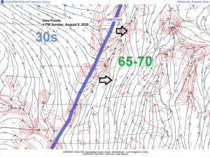
Relief is on the way for those not liking the tropical dew points we’ve had the last few days.
Dew points are expected to fall into the 40s and 50s on Monday with even some 30s over the Dakotas!
Higher dew points (muggier weather) is possible again from mid to late week.
High temperatures on Monday in northeast Minnesota and northwest Wisconsin are forecast to be in the 70s to around 80 degrees which is close to normal for August 10th.
Source: 12z NAM model 8.9.2020; https://weather.cod.edu/

Thanks for reading!
Tim
Leave a Reply