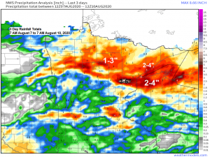
It was a wet weekend across the Northland with widespread rainfall totals of at least an inch or two, but there were pockets of much higher rainfall totals which were in the 3 to 4 inch range to even as much as 6 inches!
Here are some rainfall totals from August 7-9, 2020
2 ENE Kettle River, MN: 6.23″
2 SSE Pine River, MN: 3.25″
Ashland, WI: 2.41″
1 N Cloquet, MN: 1.65″
Duluth Airport: 1.48″
International Falls, MN: 1.47″
Brainerd, MN: 0.32″
A refreshing air mass has made its way into the upper Midwest today, check out these dew points from Monday afternoon. All the muggy stuff was over southern/eastern Wisconsin today where dew points were in the 60s and 70s.
Note: It does look a little more humid in the Northland from mid to late week as dew points climb into the upper 50s to middle 60s, but it doesn’t look like will be seeing any 70+ degree dew points again anytime soon.

Tuesday’s weather: Another very nice summer day across northeast Minnesota and northwest Wisconsin with lots of sunshine, warm temperatures and low humidity! Highs on Tuesday will be in the upper 70s to middle 80s with dew points mainly in the 40s and 50s.
Our next chance for some rain in the Northland looks to come late this week, in the Thursday-Saturday time frame, this is when we could see some showers and thunderstorms at times.
Storm Reports from around the Northland from Sunday, August 9, 2020 to Monday, August 10, 2020
Source: https://www.weather.gov/dlh/
4:12 AM (8/10) Lightning. 4 E Beroun, MN (Pine County) County call center relayed a report of lightning striking a trailer early Monday morning.
3:55 AM (8/10) Hail 1.25 inch. 3 WSW Pine City, MN (Pine County) Estimated quarter to half dollar sized hail.
3:55 AM (8/10) Hail 1.00 inch. 3 SSE Henriette, MN (Pine County) Quarter sized hail. Damage to vehicle.
5:39 PM (8/9) Thunderstorm Wind Gust. 40 mph. 5 SW Inger, MN (Itasca County)
5:35 PM (8/9) Thunderstorm Wind Gust. 52 mph. 2 SSE Squaw Lake, MN (Itasca County)
5:34 PM (8/9) Thunderstorm Wind Gust. 43 mph. 8 NNE Bena, MN (Cass County)
4:06 PM (8/9) Thunderstorm Wind Gust. 50 mph. 9 WNW Hovland, MN (Cook County)
2:25 PM (8/9) Thunderstorm Wind Damage. 1 WNW Lake Nebagamon, WI (Douglas County) Multiple pine trees snapped with a few uprooted by the Lake Nebagamon Cemetery.
1:30 PM (8/9) Thunderstorm Wind Damage. 12 W Drummond, WI (Bayfield County) Several downed trees. 1.5 inches of rain and some road erosion.
Storm reports over the last 72 hours
Red dots=Tornado reports
Blue dots=Wind reports
Green dots=Hail reports
Source: https://www.weather.gov/

A derecho has been producing widespread damage and destructive winds in Iowa and Illinois today.
Note: Check out some of the top wind gusts from today’s derecho, incredible! Source: https://www.spc.noaa.gov/
1 S Midway, IA: 112 mph
2 WNW Le Grand, IA: 106 mph
Hiawatha, IA: 100 mph
4 E Albion, IA: 99 mph
4 SSW Dixon, IL: 92 mph
3 SW Marshalltown, IA: 91 mph
Blairstown, IA: 90 mph
Atkins, IA: 90 mph
Davenport Airport: 86 mph
1 W Urbandale, IA: 85 mph
1 W Elkhart, IA: 85 mph
2 SSW Prairie City, IA: 85 mph
3 NNW Moline, IL: 85 mph
1 N Des Moines Airport: 80 mph
Jasper, IA: 80 mph
Here are the storm reports over the past 6 hours (ending 3 PM CT) with all the blue dots representing wind reports.

Here’s a look at today’s derecho on Goes-16 satellite imagery.
Source: https://weather.cod.edu/

And on radar imagery – Loop time 8 AM to 1 PM Monday, August 10, 2020.

A line of destructive thunderstorms with a history of producing winds of 70 to 100 mph blasting east into the Chicago area this Monday afternoon – MRMS radar loop ending 3:28 PM Monday, August 10, 2020.
Source: https://lab.weathermodels.com/

Thanks for reading!
Tim
Leave a Reply