A pesky MCV or Mesoscale Convective Vortex has been holding together nicely as it moves east across western and central Minnesota today. This feature has already brought some rain to southern portions of the Northland today, mainly around the Brainerd lakes and Aitkin areas. This disturbance will continue to affect parts of the Northland tonight into Thursday morning with some more rain and a few thunderstorms likely from east-central Minnesota into northwest Wisconsin. There isn’t much instability in our area late this afternoon, but elevated CAPE is forecast to increase during the night so we may see a few thunderstorms develop with heavy rain and lightning being the primary threats.
Water vapor loop from Wednesday, August 12, 2020 – Loop time 11 AM to 3:40 PM.
Source: https://weather.cod.edu/

Radar loop from Wednesday, August 12, 2020 – Loop time 10 AM to 4:45 PM.

Rainfall totals from today, Wednesday, August 12, 2020 (thru 4 PM)
https://mesowest.utah.edu/Source:
Brainerd, MN: 0.36″
Aitkin, MN: 0.31″
Moose Lake, MN: 0.01″
Most of the rain tonight looks to remain roughly along and south of Highway 2 in northeast Minnesota including over most of northwest Wisconsin with some locations in east-central Minnesota and northwest Wisconsin likely picking up over a half inch of rain by early Thursday afternoon.
18z NAM 3km model simulated radar forecast valid from 7 PM Wednesday to 7 PM Thursday.
Source: https://weathermodels.com/

Source: https://lab.weathermodels.com/

Strong to severe thunderstorms are possible across north-central Minnesota on Thursday, especially from late Thursday afternoon into Thursday night. The main hazards are from damaging winds and hail. Stay Weather Aware!
An enhanced risk for severe thunderstorms covers far northwest portions of the Northland on Thursday, roughly along and west of a line from International Falls to Northome (orange area on map)
There is a slight risk for severe thunderstorms farther south and east on Thursday including Crane Lake, Bigfork, Grand Rapids, Walker, Hibbing, Cook and Ely (yellow area on map)
A lesser chance or marginal risk for severe thunderstorms on Thursday including Grand Marais, Silver Bay, Two Harbors, Duluth, Floodwood, Aitkin, Moose Lake and Brainerd (green area on map)
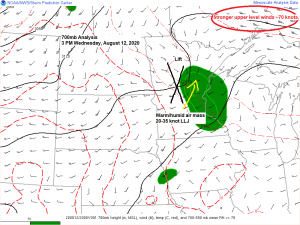
The atmosphere on Thursday looks like it could become quite unstable across northern Minnesota with CAPE 1500-3000 J/kg along with steep mid level lapse rates of 7.0-8.0 c/km. 0-6 KM and Effective Bulk Shear is forecast to remain <30 knots which is on the weaker side of things, but still should be enough shear when combined with the other ingredients to produce some strong to severe storms in north-central Minnesota Thursday or Thursday night.

A risk for strong to severe thunderstorms will carry over into Friday as well as we see a cold front move through the upper Midwest. Should have a decent amount of forcing which will spread east with this cold front, and this combined with a potentially warm, humid and unstable air mass coupled with stronger winds aloft spreading into the region sets the stage for possible severe weather Friday afternoon into Friday night across northeast Minnesota and northwest Wisconsin. Stay tuned.
Source: https://www.wpc.ncep.noaa.gov/

Two shots of cool air are looking increasingly likely for next week. The first arrives in the August 16-18 time frame, the second shot sometime in the August 21-23 time frame. Note: It doesn’t look quite cold enough for a frost threat in northeast Minnesota or northwest Wisconsin next week, but we’re inching closer to when we could start to see some frost in parts of the Northland, won’t be much longer!
Highs during the early to middle part of next week look to range from around 60 to 70 degrees in northeast Minnesota and northwest Wisconsin with overnight lows in the 40s and 50s with some 30s possible in the typical cold spots (depending on sky conditions and wind speeds at night)
Source: /https://www.tropicaltidbits.com/

Source: https://weathermodels.com/

Thanks for reading!
Tim
Leave a Reply