A couple rounds of strong to severe thunderstorms are expected across northeast Minnesota and northwest Wisconsin from late this evening through Friday evening.
Tonight’s severe weather risk is greatest across north-central Minnesota with an Enhanced risk of severe thunderstorms roughly along and west of a line from Walker to International Falls, and a Slight risk of severe thunderstorms farther southeast, including the Brainerd lakes, Aitkin, Grand Rapids, Hill City, Bigfork, Hibbing, Ely, Cook, Orr and Crane Lake areas. There is a Marginal risk of severe thunderstorms tonight including the North Shore, Duluth, Moose Lake and McGregor.
Main hazards with the storms tonight and Friday will be from heavy rain, lightning, hail and strong winds.
Here are two model forecasts showing how things could play out through Friday night.
18z HRRR model
Source: https://weathermodels.com/

18z NAM 3km model

Note: A flash flood risk does exist across north-central Minnesota late tonight and also on Friday (mainly NW of Duluth) This risk will increase if thunderstorms begin to move over the same location for a few hours, if this occurs we could see a quick 2 to 4 inches of rain!
Source: https://lab.weathermodels.com/

Tonight’s storms will primarily be with a warm frontal boundary which is over north-central Minnesota late this afternoon. Thunderstorms should develop in eastern North Dakota and northwest Minnesota through early this evening, then we could see these storms either lift ENE across northern Minnesota during the night, or these storms could drop SSE into central and southern Minnesota later tonight.
Source: https://www.spc.noaa.gov/

There is plenty of fuel for storms tonight with Mixed Layer CAPE >4000 J/kg across the eastern Dakotas and far western Minnesota. Southerly low level jet over Minnesota will help advect this pool of strong instability NNE into the Northland tonight which should help sustain any storms that move into western portions of the area this evening and overnight. Lapse rates are also very steep late this afternoon ranging from 8.0-8.5 C/km thanks to an elevated mixed layer which was over the Western High Plains, this EML or elevated mixed layer will remain in place through Friday, although the mid level lapse rates might not be quite as impressive Friday afternoon as they are tonight, but should still be in the 7.0-7.5 C/km range the way it looks now.
Note: One ingredient which is lacking for severe weather tonight is the amount of wind shear as 0-6 KM and Effective Bulk Shear will remain generally less than 30 knots through the night which is certainly on the weaker side of things for severe weather.

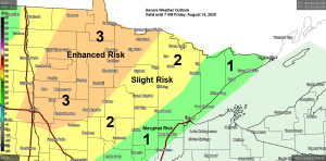
The risk of strong to severe thunderstorms covers the entire Northland on Friday with most of the area either in an Enhanced or Slight risk of severe thunderstorms (orange and yellow areas on map respectively) Only the tip of the Minnesota Arrowhead and far eastern portions of northwest Wisconsin are in a lesser risk/Marginal for severe storms on Friday.
One limiting factor on Friday is the amount of wind shear once again with 0-6 KM and Effective Bulk Shear forecast to only be at around 30 knots which is on the weaker side of things for severe storms, but with the amount of forcing and stronger winds aloft spreading into the area, this could make up for the lack of stronger wind shear.
I’d say there is also some concern as to how quickly the atmosphere can recover after tonight’s activity. Should clouds, rain and storms stick around much of Friday, this could keep instability much lower than what models are showing for Friday and this could reduce the risk for severe weather come Friday afternoon into Friday evening across the Northland. Stay tuned.
Stay Weather Aware tonight and Friday!

Tropical air mass has returned today after a few days break. Dew points of 70 degrees or higher as far north as Grand Rapids, Solon Springs and Hayward late this afternoon.
A muggy air mass will stick around through Friday evening with dew points in the 60s to lower 70s.

Will have plenty of forcing for storms through Friday evening due to the different boundaries which will be moving through the Northland, as well as with an approaching mid/upper level trough which moves ENE out of the Northern Plains on Friday.
Things quiet down in our area by late Friday night into Saturday afternoon as low pressure and cold front exits to the north/east.
Source: https://www.wpc.ncep.noaa.gov/


Note: There could be a few showers and thunderstorms in northeast Minnesota and northwest Wisconsin Saturday night as another cold front moves SE across the area.

Quite a bit of energy heading ENE out of the Northern Rockies today on its way into the upper Midwest for Friday. You can tell that Autumn is not far away as these low pressure systems and troughs are becoming a little stronger compared to how they were earlier in the summer.
Water vapor loop from Thursday, August 13, 2020
Source: https://weather.cod.edu/

Thanks for reading!
Tim
Leave a Reply