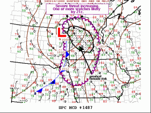
The Storm Prediction Center is monitoring much of central and southwest Minnesota for an increasing severe weather threat this afternoon with one or more watches likely by late this afternoon (by around 4 PM) There’s a 95% chance will see one or more watches issued by late this afternoon by the SPC.
***Update as of 2:43 PM Friday*** Tornado Watch has been issued for western and central Minnesota until 8 PM this evening (red area on map) This watch is just outside of the Northland. Primary threats in the watch area include a couple tornadoes, large hail to 2 inches in diameter and damaging wind gusts to 70 mph.
Source: https://www.spc.noaa.gov/

Lingering clouds and rain this morning and early this afternoon have really hampered the northward extent of instability across the Northland.
Just a whole lot of clouds across most of the Northland today, and this is holding temperatures down, and is also keeping instability lower than what model guidance has been showing for today.
Goes-16 visible loop from 10 AM to 1:50 PM, Friday, August 14, 2020.
Source: https://weather.cod.edu/

The highest CAPE or most unstable air remained over the southern half of Minnesota as of 1 PM Friday with lower amounts of CAPE or instability farther north across northeast Minnesota and northwest Wisconsin.
It’s possible will see the CAPE increase a bit across northeast Minnesota and northwest Wisconsin by late this afternoon, but I don’t think will see values much greater than 1000-1500 J/kg up in our area due to the lingering cloud cover this afternoon.

The overall setup is still a good one for getting thunderstorms and possibly some severe weather, however, as low pressure deepens a bit as it heads northeast out of the eastern Dakotas while a warm front (red line on map) lifts NNE followed by a cold front (blue line on map) which will push ENE through this evening.
This system has a lot of energy as shown by the stronger wind field aloft with 500mb winds increasing to >50 knots while out ahead of this system a low level jet increases to around 30-45 knots – This 850mb jet will help maintain a warm/moist advection pattern across the Northland through early this evening while also helping to increase the instability just a bit.
Wind shear has increased as well this afternoon as this low pressure system and upper level trough approaches from the west. Effective Bulk Shear and 0-6 KM Shear ranged from 30 to 40 knots, while the 1km Shear was in the 25 to 35 knot range over western and central Minnesota. Storm Relative Helicity values as of 1 PM ranged from 200 m2/s2 to 400 m2/s2 across west-central Minnesota which raises some concern for tornado potential through early this evening in western and central Minnesota.

This system is deepening this afternoon with dry air blasting east out of central North Dakota.
As this system and all of its forcing moves NE, the mass response in the atmosphere should be for scattered to numerous thunderstorms across Minnesota with some severe storms likely through this evening.
Note: The greatest threat for severe weather has shifted to central and southern Minnesota where damaging winds, large hail and isolated tornadoes are possible through this evening, but there is still at least a chance for a few severe storms in northeast Minnesota and northwest Wisconsin with damaging winds and hail through this evening, with even an isolated tornado threat around the Brainerd Lakes area.
Source: https://lab.weathermodels.com/

Goes-16 water vapor loop from 9 AM to 1:50 PM Friday, August 14, 2020.
Source: https://weather.cod.edu/

Radar loop from 11 AM to 2:10 PM Friday, August 14, 2020.

Storm Reports from Friday, August 14, 2020
Source: https://www.weather.gov/dlh/
10:55 AM: Heavy Rain 1.25″. Breezy Point, MN (Crow Wing County)
10:53 AM: Heavy Rain 1.40″. Ranier, MN (Koochiching County)
9:33 AM: Heavy Rain 1.25″. 2 SSE Pine River, MN (Cass County)
9:19 AM: Heavy Rain 2.06″. 3 SW Pine Center, MN (Crow Wing County)
6:23 AM: Heavy Rain 2.06″. Bigfork, MN (Itasca County)
4:00 AM: Thunderstorm Wind Damage. 5 SE Oliver, WI (Douglas County) Wind flipped patio table and 3 to 4 gallon plant pots knocked over.
2:10 AM: Thunderstorm Wind Damage. Nisswa, MN (Crow Wing County) Several trees blown down.
1:25 AM: Hail 0.75 inch. Whipholt, MN (Cass County)
12:15 AM: Thunderstorm Wind Damage. Marcell, MN (Itasca County) A few downed trees reported.
Some additional rainfall reports through 2 PM Friday, August 14, 2020
Source: https://mesowest.utah.edu/
Aitkin, MN: 2.01″
Walker, MN: 1.75″
International Falls, MN: 1.40″
McGregor, MN: 1.10″
Grand Rapids, MN: 1.09″
Chisholm-Hibbing Airport: 0.73″
Cook, MN: 0.45″
Cloquet, MN: 0.25″
Silver Bay, MN: 0.21″
Grand Marais Airport: 0.18″
Duluth Airport: 0.13″
Solon Springs, WI: 0.12″
Superior Airport: 0.08″

Thanks for reading!
Tim
Leave a Reply