Scattered showers and thunderstorms are expected to develop over parts of the Northland tonight into Wednesday morning as a warm front lifts north out of south-central Minnesota, while low level warm/moist advection takes place north of that boundary tonight. An area of strong instability ranging from 1500-3000 J/kg will lift NE out of central Minnesota tonight thanks to a SW low level jet which is forecast to increase to around 30-40 knots, so there should be enough instability for thunderstorms tonight, but getting them to develop may be difficult.
A hot/capped air mass sitting over the Northern Plains will make it difficult for thunderstorms to develop tonight, and the leading edge of this capped air mass will make it into western/southern parts of the Northland tonight, so we could see most of the thunderstorms develop more in the #1 outlined area on the map with very little storm development in the #2 area. Timing of when these storms develop remains uncertain, it’s possible that storms won’t begin to develop until between Midnight and 4 AM tonight with isolated activity possible prior to then.
Source: https://www.spc.noaa.gov/

Goes-16 visible loop from today kind of tells the story – Clouds across north-central Minnesota pushing ESE, and those clouds are found NE of a cap or area of very warm temperatures aloft. Eventually those clouds across northern Minnesota may develop into thunderstorms tonight, but when is the million dollar question.
Source: https://weather.cod.edu/

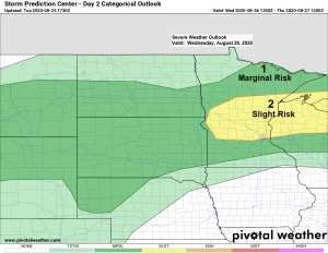
Isolated strong to severe thunderstorms capable of producing hail up to quarter size and wind gusts >50 mph are possible later tonight into Wednesday morning over northeast Minnesota and northwest Wisconsin. Storms will also be capable of producing downpours and lightning.
Source: https://www.pivotalweather.com/

Source: https://lab.weathermodels.com/

Another hot day across southern Minnesota with widespread temperatures in the lower 90s this afternoon while farther north temperatures ranged from the mid 70s to low 80s today.
Source: RTMA model; https://lab.weathermodels.com/

A muggy air mass with 65 to 70 degree dew points across central and southern Minnesota today will be moving NE into the Northland for Wednesday, but only for a day before drier air moves in once again on Thursday.
Source: RTMA model

A warm front (red) and cold front (blue) will remain over the Northland on Wednesday before both boundaries exit to the south/east by Thursday morning.
Additional scattered showers and thunderstorms are possible Wednesday afternoon through Wednesday evening over parts of the Northland, primarily from east-central Minnesota into northwest Wisconsin, this is where the greatest instability is forecast to develop Wednesday afternoon with CAPE possibly >2000 J/kg. Strong winds aloft and favorable amounts of wind shear will be present which leads to the possibility for a few strong to severe thunderstorms on Wednesday, again mostly from east-central Minnesota into northwest Wisconsin. Hail and strong wind gusts will be the primary hazards with the stronger storms on Wednesday.
Source: https://www.wpc.ncep.noaa.gov/

…Long Range Forecast…
-Rain chances could return to parts of the Northland Thursday night or Friday, but at the moment it looks like most of this rain will remain south of our area, with only a few showers possible across northeast Minnesota and northwest Wisconsin.
-Our next shot for some rain comes Sunday night into Monday (August 30th-31st) and behind this system we should see some cooler air work its way into the upper Midwest, but it doesn’t look all that chilly as daytime highs are still expected to get into the 60s to lower 70s between August 31st-September 2nd while overnight lows dip into the 40s, so yes a little cooler, but nothing really out of the ordinary for the time of year, and right now it doesn’t look like temperatures would be cold enough at night to produce frost anywhere in the Northland at least through September 2nd.
4 PM update on Hurricane Laura
Source: https://www.nhc.noaa.gov/
Location about 480 miles southeast Lake Charles, Louisiana or about 510 miles southeast of Galveston, Texas. Movement was to the west-northwest at 17 mph. Maximum sustained winds of 80 mph with a minimum central pressure of 990mb or 29.24 inches. Laura is currently a category 1 hurricane.
Laura is forecast to make landfall over or near the Upper Texas Coast sometime early Thursday morning. Laura is expected to intensify to a major hurricane, possibly reaching category 3 or 4 status prior to it making landfall.

Goes-16 one hour mesoscale satellite loop of Laura from 3:14 PM to 4:14 PM CT, Tuesday, August 25, 2020. Note the black and white colors which indicate cloud top temps of -80 to -90C this afternoon.
Source: https://weather.cod.edu/

Here’s the 12z European model forecast track of Laura valid from 7 PM Tuesday to 7 AM Friday – Note the rapid drop in pressure between this evening (~980mb) to Wednesday evening (~940mb) and the pressure may even drop a little lower than that, possibly bottoming out at around 937mb by late Wednesday evening.
Source: https://weathermodels.com/

Wind gusts >130 mph are possible Wednesday evening into early Thursday morning over the Upper Texas Coast as Laura heads toward that area per 12z European computer model.

Thanks for reading!
Tim
Leave a Reply