A cold front is working its way through the Northland this afternoon. Favorable ingredients are in place for thunderstorm development and even a few strong to severe storms late this afternoon over northwest Wisconsin with high amounts of CAPE, favorable wind shear and stronger winds aloft, but very warm temperatures in the mid/upper levels of the atmosphere (cap) will make it difficult for severe weather development as a cold front continues to move SE across the area through the evening.
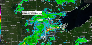
A nice area of thunderstorms blew up just west of Duluth late this afternoon and these storms are currently moving through the Twin Ports as of 5:15 PM with some lightning and torrential rainfall. Bulk of this activity is affecting the southern portions of Duluth, not much happening on the north side of the city. These storms are moving off to the east and will be followed by some more showers through about mid evening.

Note the brighter colors to the cloud tops toward the end of this satellite loop, these were the storms that developed near Duluth late this afternoon.
Source: https://weather.cod.edu/

Will likely see some rain showers and a few thunderstorms affect parts of northeast Minnesota and northwest Wisconsin through the evening with brief downpours and occasional lightning, but the risk for stronger storms is low due to the cap that is in place.
Source: https://www.spc.noaa.gov/

The northern edge of a late August heat wave worked its way into southern parts of the Northland this afternoon with temperatures reaching the middle 80s as far north as Duluth (86 F at the Airport) while even hotter temperatures were found farther south. Note: The heat index at the Duluth Airport at 4 PM today was 91 degrees! No record heat in Duluth today, however, as the record high for August 26th is 93 degrees which was set in 1937.
A cooler air mass arrives on Thursday with highs mainly in the 70s in northeast Minnesota and northwest Wisconsin.
Source: RTMA model; https://lab.weathermodels.com/

Today may very well have been the final time this summer with 70 degree dew points in our area. A much more comfortable air mass moves in on Thursday with dew points a good 15 to 20 degrees lower compared to what we’re seeing this afternoon.
Source: RTMA model

Looks mainly dry across the Northland on Thursday, but a few showers are could return Thursday night into Friday as another cold front moves SE out of Northern Plains. Note: A bigger concern from late Thursday afternoon into Thursday night will be the potential for heavy rain and flash flooding across southern Minnesota and southern Wisconsin.
Source: https://www.wpc.ncep.noaa.gov/

…Hurricane Laura Update…
4 PM CDT Advisory, Wednesday, August 26, 2020
Source: https://www.nhc.noaa.gov/
Laura has strengthened to a powerful category 4 hurricane this afternoon with maximum sustained winds of 145 mph. Laura was located about 155 miles south of Lake Charles, Louisiana, or about 155 miles south-southeast of Port Arthur, Texas. Movement was to the northwest at 15 mph. The minimum central pressure of Laura was 947mb/27.97 inches.
Based on its current movement, Laura should make landfall later tonight somewhere between Sabine Pass and Cameron.

Some key messages from the National Hurricane Center
"STORM SURGE:  The combination of a dangerous storm surge and the
tide will cause normally dry areas near the coast to be flooded by
rising waters moving inland from the shoreline.  The water could
reach the following heights above ground somewhere in the indicated
areas if the peak surge occurs at the time of high tide...

Johnson Bayou LA to Rockefeller Wildlife Refuge including Calcasieu
Lake...15-20 ft
Sea Rim State Park TX to Johnson Bayou LA including Sabine
Lake...10-15 ft
Rockefeller Wildlife Refuge to Intracoastal City LA...10-15 ft
Intracoastal City LA to Morgan City including Vermilion Bay...8-12
ft
Port Bolivar TX to Sea Rim State Park...6-9 ft
Morgan City LA to Mouth of the Mississippi River...4-7 ft
Freeport TX to Port Bolivar including Galveston Bay...2-4 ft
Mouth of the Mississippi River to Ocean Springs MS including Lake
Borgne...1-3 ft
Lake Pontchartrain and Lake Maurepas...1-3 ft

The deepest water will occur along the immediate coast near and to
the right of the landfall location, where the surge will be
accompanied by large and destructive waves."
"Unsurvivable storm surge with large and destructive waves will cause
catastrophic damage from Sea Rim State Park, Texas, to Intracoastal
City, Louisiana, including Calcasieu and Sabine Lakes. This surge
could penetrate up to 40 miles inland from the immediate coastline,
and flood waters will not fully recede for several days after the
storm."
Goes-16 mesoscale floater one hour sandwich satellite loop of Hurricane Laura from Wednesday, August 26, 2020 (loop time 3:35 PM to 4:35 PM CT)
Source: https://weather.cod.edu/

Goes-16 lower level water vapor loop from Wednesday, August 26, 2020
Loop time 12:01 PM to 4:41 PM CDT.

Laura will make landfall as a major hurricane late tonight over the Upper Texas and southwest Louisiana coasts.

I’d say the chances are pretty good that some parts of the Northland (especially away from Lake Superior) will get their first frost within the next 2 weeks which really isn’t that unusual.
Check out the record first frost dates across the Northland
Duluth: August 27, 1986
International Falls: August 20, 1907
Brainerd: August 6, 1977
Hibbing: August 13, 2004
Ashland: August 18, 1950
Hayward: August 20, 1934
And here’s the average date for the first frost across the Northland
Duluth: September 30
International Falls: September 14
Brainerd: September 21
Hibbing: September 15
Ashland: September 18
Hayward: September 14
Looks like September is going to open cooler than average across northeast Minnesota and northwest Wisconsin.
Source: 12z European ensemble model 8.26.2020; https://weathermodels.com/


Thanks for reading!
Tim
Leave a Reply