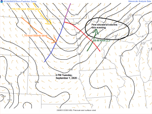
The system affecting the Northland tonight is quite strong, but is lacking moisture, but there is still strong enough forcing to overcome the lack of moisture to produce some rain showers especially before Midnight. A few thunderstorms are even possible this evening thanks to a strong low level jet which is resulting in a strong warm air advection pattern over our area which is helping to generate some weak instability this evening.
Radar from 6 O’clock shows a few light showers and sprinkles moving quickly ENE across northeast Minnesota, while an area of showers and thunderstorms heads ESE out of northwest Minnesota (note the lightning strikes) All of this activity should be out of the Northland by later tonight.

NAM 3km model showing the two systems which will be affecting the Northland through Thursday.
System one moves through mainly before Midnight tonight with some showers and isolated thunderstorms, this will be followed by mainly dry conditions on Wednesday, and then a second system moves through Wednesday night and Thursday bringing more showers to the Northland.
Source: https://weathermodels.com/

Here’s a look at the rainfall forecast through Thursday evening – Greatest amounts are expected to remain over far northern Minnesota with a half inch or more of rain, while around a tenth inch or less of rain is expected from Hill City to the Twin Ports east-southeast through most of northwest Wisconsin.
Source: https://lab.weathermodels.com/

A lot of clouds over the Northland today which helped keep temperatures a bit cooler than what was forecast for today. Instead of some lower 70s, the entire area was stuck in the 60s this afternoon.
Source: Goes-16 visible satellite loop from Tuesday, September 1, 2020; https://weather.cod.edu/

An active weather pattern in place on this first day of meteorological fall 2020.
A strong low pressure system is lifting NE across Hudson Bay Canada today, while another system moves east affecting northern Minnesota tonight, with a third system in the pipe line across northwestern Canada today.
Source: Goes-16 water vapor imagery, Tuesday, September 1, 2020.

A potent low pressure system will be impacting northeast Minnesota and northwest Wisconsin Wednesday night into Thursday, this system will bring some rain showers to the area, but the bigger story with this low will be the strong gusty winds that will accompany it. Winds will start out from the southwest Wednesday night, then shift to the west-northwest on Thursday. Wind gusts of 20 to 30 mph are possible across the Northland for Wednesday night and Thursday with higher gusts possible, especially near Lake Superior.
Source: 12z HREF model 9.1.2020; https://www.spc.noaa.gov/

Note: Gale warnings and Gale Watches have been issued for Lake Superior for Thursday. The largest waves are expected to remain east of the North Shore and Twin Ports as winds will be out of the west to northwest (offshore wind direction for the North Shore)

Check out the temperature forecast for Wednesday afternoon – Widespread 80s to near 90 degree temps from the Dakotas into southwest Minnesota, this area of warmth won’t make it into the Northland, however, due to a strong low and cold front which moves through Wednesday night which will push the warmer air further to the south for Thursday.
Source: 18z RGEM model 9.1.2020; https://www.tropicaltidbits.com/

Thanks for reading!
Tim
Leave a Reply