Severe thunderstorms are expected to impact much of southwest and south-central Minnesota late this evening into early Sunday morning (10 PM to 5 AM time frame) The main threat is from large hail – Up to golf ball size hail and possibly even a little larger late tonight especially in the Enhanced risk area. Note: A lesser risk for severe weather extends as far north as the Brainerd Lakes area after Midnight tonight (dark green area on map)

Ingredients are coming together for a severe weather event late tonight into early Sunday morning over parts of southern Minnesota.
High amounts of elevated CAPE of 2000-4000 J/kg currently over eastern Nebraska and far southeast South Dakota will be advected ENE into southern Minnesota on a strong southwesterly low level jet tonight.
Source: https://www.spc.noaa.gov/

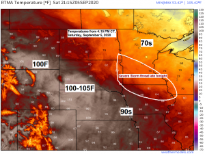
An impressive EML (elevated mixed layer) covered the Rockies and western High Plains today with very dry dew points in the single digits, 10s and 20s while hot temperatures of 95 to around 105 degrees were found over those same areas.
Mid level lapse rates were very steep this afternoon ranging from 8.0 to 9.5 C/km, a plume of these steep lapse rates will advect ENE into parts of Minnesota late tonight. This will increase the potential for large hail as severe storms develop late tonight in western/southern portions of Minnesota.

Source: https://lab.weathermodels.com/

A few showers or thunderstorms could move through parts of the Northland overnight thru around mid-morning Sunday, but the greater chance for storms and severe weather should remain farther off to the south.
Otherwise our weather in the Northland for Sunday will feature highs in the middle 60s to middle 70s with a southerly wind 10 to 20 mph becoming northwest late in the afternoon/evening at 15 to 30 mph with higher gusts possible.
20z (3 PM) HRRR model simulated radar forecast valid from 7 PM Saturday to 9 AM Sunday.
Source: https://weathermodels.com/

Elevated supercells (rotating updrafts) capable of producing large hail late tonight across south-central Minnesota as seen on the 20z HRRR model Updraft Helicity forecast ending at 9 AM Sunday. Note: Yellow, orange and red colors on the map indicate a higher likelihood for rotating storms.

Seeing some wildfire smoke move over parts of the Northland this afternoon, and some of this smoke could linger at times into Sunday before getting pushed farther south and out of our area by Sunday night.
Source: https://weather.cod.edu/

A wet weather pattern could develop from southern Minnesota to central Wisconsin during the early to middle part of next week with potential for 1 to 3 inches or more of rain. Most of this rain looks like it will stay SE of the Northland next week.
Source: https://lab.weathermodels.com/

Right back into a dry weather pattern in northeast Minnesota and northwest Wisconsin.
Chances for getting a significant rainfall over the next 2 weeks looks pretty low at the moment.
Source: 12z European ensemble model 9.20.2020; https://weathermodels.com/

Note: Duluth continues to run well below normal in precipitation this year with a precipitation deficit of nearly -7.00 inches below normal thru September 5th. I don’t think we’re going to erase this deficit by the end of the year.
8% of Minnesota remains in Moderate Drought (orange areas on map) as of September 1st, while 26% of the state is Abnormally Dry (yellow areas on map)
Source: https://droughtmonitor.unl.edu/

Overnight temperatures the past 2 nights have been cool enough to where some patchy frost could have formed across parts of the Northland.
The air mass moving in for the early to middle part of next week looks even cooler compared to the past two nights, so I’d say the chances are pretty good that much of the Northland (especially away from Lake Superior) will see a frost and or freeze sometime between September 7th-10th.
Check out some of these low temperatures from Saturday morning, September 5, 2020.
Source: https://www.weather.gov/dlh/
| 2 S Tower, MN: 33 F Crane Lake, MN: 34 F International Falls, MN: 35 F 2 E Celina, MN: 35 F Hibbing, MN: 37 F Grand Marais Airport: 37 F Cook, MN: 37 F Eveleth, MN: 37 F Aitkin, MN: 37 F Babbitt, MN: 37 F 3 E Orr, MN: 37 F Solon Springs, WI: 37 F |
We are still looking at a major pattern change for next week as much colder temperatures push quickly south/east out of the northern Rockies – Here’s the temperature anomaly forecast valid from September 6th thru 12th, 2020.
Below normal temperatures represented by blue, green and purple colors on the map.
Source: 12z European ensemble model 9.5.2020; https://weathermodels.com/

It still looks like most of the Northland will be stuck in the 50s for daytime highs Monday, Tuesday and Wednesday, September 7th-9th, and there is even a chance that a few locations might struggle to climb out of the upper 40s next Tuesday or Wednesday. Note: Normal highs across the Northland in early September are in the upper 60s and lower 70s.
Temperature anomaly forecast valid from September 7th to September 12th, 2020.
Source: 12z European ensemble model 9.5.2020

Along with the much colder temperatures comes a chance for the first snowfall of the season next week across the central and southern Rockies and western High Plains. Most of this snow looks to fall in the Monday-Wednesday, September 7th-9th time frame, and the snow will spread from north to south.
Source: 12z European ensemble model 9.5.2020

Thanks for reading!
Tim
Leave a Reply