We’ve seen a few showers and thunderstorms develop this afternoon over far eastern Minnesota and northwest Wisconsin with brief downpours and some lightning occurring with this activity today – Radar Rainfall Estimates thru 4 PM Monday show anywhere from a trace to nearly a half inch of rain with those isolated storms today.

Cloud tops with this afternoon’s storms have been around 30 to 40,000 feet per radar and satellite imagery.
Goes-16 sandwich imagery from Monday, September 21, 2020 – Loop time ends at 4:06 PM CT.
Source: https://weather.cod.edu/

MRMS radar loop from Monday, September 21, 2020 – Loop time ends at 4:10 PM CT.
Source: https://lab.weathermodels.com/

Still seeing a lot of warm air across the Northern Plains and upper Midwest today with temperatures in the 70s and 80s.
Expect more 70s in northeast Minnesota and northwest Wisconsin Tuesday afternoon and Wednesday afternoon, with even a shot at 80 degrees in a few locations.
We could see areas of low clouds and fog develop over parts of the Northland later tonight into Tuesday morning, but whatever forms should burn off by mid or late Tuesday morning.
Note: Cooler air moves in on Thursday, especially for areas near Lake Superior as winds become northeasterly.

What a nice looking low heading out of Manitoba and into Ontario today per Goes-16 imagery – Loop time ends 4:50 PM CT, Monday, September 21, 2020.
Source: https://weather.cod.edu/

There is some hope for those wanting some rain around here as the computer models have been trending a little wetter for the rest of this month, in fact we may see near to slightly above normal precipitation across the Northland for the rest of this month. Will see what happens.
Note: Duluth hasn’t even picked up a half inch of rain this month. We’re sitting at 0.43″ for the month (thru the 21st) which is nearly 2.50″ below normal for September, and we’re around 9.00″ below normal for the year.
Source: https://weathermodels.com/

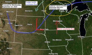
Our next best chance to get some rain in the Northland comes Wednesday afternoon or Wednesday night as showers and thunderstorms develop near a cold front which moves southeast out of northern Minnesota later in the day on Wednesday.
Computer models today (Monday) do show some instability developing in our area on Wednesday with CAPE possibly reaching 1000 J/kg, this coupled with an area of steep mid level lapse rates of 7.0-8.0 c/km should be enough to get some scattered storms to develop over the Northland as long as we get enough lift with the approaching cold front. Looks like will have enough moisture in place as well with this midweek front, with dew points in the mid 50s and low 60s, while Precipitable Water builds to ~1.25 to 1.50 inches.
Here’s the NAM 3km model simulated radar forecast for Wednesday (ending at 1 AM Thursday)
Source: https://weathermodels.com/

An early look at rainfall totals for late Wednesday and Thursday shows a potential for around a quarter to half inch of rain across the Northland. Will see if these amounts increase or decrease over the next 24-36 hours.
Source: https://lab.weathermodels.com/

As mild as it will be this week, next week has a chance to be quite a bit cooler, but it depends on which model you want to believe.
The Euro ensemble (EPS) is more bullish with the chilly air, covering areas from the Northern Plains to the Great Lakes, Ohio Valley into the southern U.S.
Note: Daytime highs could be stuck in the 40s and 50s across the Northland next week if the EPS is on the right track.
Source: https://weathermodels.com/

However, the GEFS is warmer across the Northern Plains and most of the upper Midwest, while chillier temperatures setup a bit farther east compared to the EPS model.
Stay tuned!
Source: https://www.tropicaltidbits.com/

Here are some photos I took from the St. Louis River area in Fond du Lac (Duluth) Minnesota on Sunday, September 20th, 2020.
St. Louis River – Fall foliage and some fog coming off the river on a calm Sunday morning.


A smoky sunrise in the Twin Ports from Sunday morning, September 20th, 2020.


Lots of beach erosion on Park Point from previous storms over the last several years. Strong east-northeast winds with those aforementioned storms lead to large waves over western Lake Superior, which then crash ashore which leads to erosion on the sandy beach of Park Point.
Photos from Sunday, September 20th, 2020.


Thanks for reading!
Tim
Leave a Reply