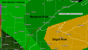
There is a chance for a few strong to severe thunderstorms late this afternoon into early this evening over far northern Wisconsin, with a lesser chance extending further west into east-central and northeast Minnesota including the Twin Ports.
Note: The risk for a few severe storms later today is greatest roughly along and east of a line from Port Wing to Minong, including cities such as Iron River, Washburn, Bayfield, Ashland, Glidden, Hayward, Winter, Loretta, Upson and Hurley.
An area of low pressure over western Minnesota late this morning is forecast to track ENE through this evening while a warm front extending east of this low lifts north out of central Minnesota and central Wisconsin.

An area of rain and some embedded thunderstorms have been moving ENE across far northern Minnesota over the last few hours. No severe weather is expected with this area of storms, but occasional lightning and downpours will continue as these storms move to the ENE over the next few hours.
Clouds are decreasing a bit over northwestern Wisconsin early this afternoon which will allow for further surface heating and increasing amounts of instability over the next few hours.

The setup for severe weather is pretty good for late this afternoon, but warm temperatures aloft (cap) of around +20C at 850mb, and +10C at 700mb will be lifting NE into northern Wisconsin by late this afternoon, and this could make it difficult for thunderstorms to develop, but if they do the parameters that will be in place will be favorable for storm organization, with a threat for large hail, damaging winds and isolated tornadoes.
Severe weather ingredients in northern Wisconsin for later today include
Strong winds aloft ranging from around 50-70 knots at 500mb, and around 80-90 knots at 300mb while a low level jet increases to around 30-40 knots. Surface to 6 KM Wind shear of up to 60 knots, and Surface to 1km Shear of around 30 knots, all these are favorable for severe storms.
As for the amount of potential energy – Looks like will have around 1000 to 1500 J/kg of CAPE while mid level lapse rates range from around 7.0-8.0 c/km per model forecasts. Enough energy for storms, plus the steep lapse rates will increase the potential for large hail development.
Winds will be changing direction with height later today with southeast winds near the surface shifting SW higher up in the atmosphere, this could cause a few thunderstorms to rotate (supercells) with a threat for hail larger than golf ball size, and maybe even a tornado.
Note: The time frame for possible severe weather looks to be from around 5 PM to 10 PM today. Stay Weather Aware!
Plenty of low level moisture (juice) in the air today with upper 50s and middle 60s dew points lifting NE out of central and eastern Minnesota early this afternoon.

Quite a bit of lift in the atmosphere moving through the Northland through this evening with the surface low and surface frontal boundaries, plus the trough approaching from the Dakotas, unfortunately it doesn’t look like Duluth and Superior will get much rain out this system, as the best chances for rain remain north and east of the Twin Ports.

Thanks for reading!
Tim
Leave a Reply