A few showers and thunderstorms are possible over parts of northeast Minnesota and northwest Wisconsin late tonight, mostly in the 1 AM to 6 AM time frame.
A mild and breezy day is ahead for Friday, although the day may start out a little cool (it is October after all) but temperatures are expected to warm into the 70s across most of the Northland Friday afternoon. Southwest winds will increase to 15 to 30 mph during the afternoon.
…Record High Temperatures for October 9th…
Brainerd: 83 F set in 1938
Ashland: 82 F set in 1930
International Falls: 80 F set in 1955, tied in 1960
Hibbing: 79 F set in 1938, tied in 1960
Duluth: 76 F set in 1930, tied in 1955 and 1960.
Note: Out of those records above, I think Duluth has the best chance at possibly tying or breaking their record high temperature for October 9th, the other records should be safe.
Cooler weather is in store for Saturday with highs in the lower 50s to lower 60s. East winds develop on Saturday and could increase to around 20 mph near Lake Superior later in the day.
A warm front approaching from the southwest coupled with a strong SW low level jet of around 45-60 knots will advect warm air and increasing amounts of elevated CAPE into the Northland tonight, and this could be enough to produce a few showers and storms overnight, but coverage looks fairly isolated and we’re not looking at any widespread or significant rainfall as locations that may get a shower are looking at rainfall totals of <0.10″ overnight.
18z NAM 3km model radar forecast valid from 7 PM this evening to 7 AM Friday.
Source: https://weathermodels.com/

We’re already seeing an increase in mid level clouds along with some ACCAS clouds across parts of the Northland late this afternoon, this is a sign that the atmosphere (at least in the mid levels) are becoming unstable.
Also of note is the wildfire smoke (milky look on the image below) across parts of the Dakotas and southern Minnesota this afternoon, some of this smoke will push into the Northland tonight and Friday.
Source: https://weather.cod.edu/

The last time Duluth picked up a quarter inch or more of rain was on September 1st, or 37 days ago/over 5 weeks ago!
0.50″ of precipitation in Duluth over the last 30 days (September 7th-October 6th) this is just 13% of our normal precipitation of 3.98″ from September 7th thru October 6th.
Here’s a look at when our last 70 degree temperature of the year has occurred at Duluth, Minnesota from 2015-2019.
| 2015: October 11th 2016: November 6th 2017: October 20th 2018: September 24th 2019: October 9th 2020: October 9th??? Note: The mean date for last 70 degree temperature in Duluth is October 9th (1874-2019 climate period) Note: Latest last 70 degree temperature in Duluth occurred on November 9th, 1999. |
Strong warm air advection will develop across the Northland tonight with 850mb temperatures peaking in the +15 to +20C range on Friday.

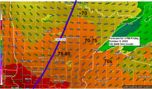
Those 70s over the Dakotas and western Minnesota this afternoon will move farther east on Friday, with much of the Northland seeing high temperatures near or above 70 degrees on Friday, and there is even a chance that a few locations such as Brainerd and Hinckley get up close to 80 degrees Friday afternoon.

Drought monitor update as of October 6th, 2020.
Source: https://droughtmonitor.unl.edu/
0.35% of Minnesota is in D2 or Severe Drought, up from 0% last week.
Nearly 12% of Minnesota is in D1 or Moderate Drought, up from 8 % last week.
Nearly 48% of Minnesota is Abnormally Dry, up from 45% last week.

1% of Wisconsin is in D1 or Moderate Drought, up from 0% last week.
19% of Wisconsin is Abnormally Dry, this is unchanged from last week.

The next best chance for a widespread rainfall looks to come Sunday night and Monday as a low pressure system with its warm front and cold front moves across the Northland, this system may even produce a few strong thunderstorms late Sunday afternoon over parts of the eastern Dakotas and west-central/southwest Minnesota.

An early look at rainfall amounts for the system late this weekend shows a potential for widespread one inch or greater rain totals across the Northland, so right now it looks like it could be a decent rain event, but we’ve seen this numerous times over the last few months where the models look impressive a few days in advance to only back away and decrease rain amounts as it gets closer in time.
Source: https://lab.weathermodels.com/

Thanks for reading!
Tim
Leave a Reply