Temperatures will be quite a bit cooler across the Northland on Saturday especially when you compare them to the highs we saw on Friday, and wow what a warm day it was, with Duluth breaking their record high temperature for October 9th, while Brainerd, Hibbing and Ashland came within 1 to 3 degrees from tying their record high temperature for October 9th.
Highs on Saturday are forecast to range from the lower 50s to the upper 50s with a few 60 degree temps possible around the Brainerd, Aitkin and Hinckley areas. Temperatures will trend warmer on Sunday with highs in the 60s to around 70 degrees, but it will be cooler near Lake Superior.
Note: East winds will also develop this weekend with gusts to around 20-25 mph possible late Saturday into Sunday.
Note: Duluth, Minnesota: A new record high temperature set for October 9th with a high today of 80 degrees. The old record high for October 9th was 76 degrees set in 1930, tied in 1955 and 1960.
So I did some digging or research or whatever you wanna call it, but anyways I wanted to find out how many years there have been since weather records have been kept in Duluth ( dating back to 1874) where we’ve seen the last 80 degree temperature occur on or after October 9th. Turns out there’s been 10 years, and now 11 years where Duluth has seen their last 80 degree temperature occur on or after October 9th. Years where this has happened are…1901, 1929, 1938, 1947, 1953, 1955, 1956, 1961, 1995, 2015 and now 2020.
Note: The latest date for last 80 degree temperature in Duluth was on October 21st (1901) and the average date for last 80 degree temp in Duluth is September 11th (1874-2020 climate period)
This is likely the final time this year that we see temperatures this warm in our area. Highs today were some 20 to 25 degrees above normal!

Source: https://lab.weathermodels.com/


Quite a temperature contrast today with 30s and even some upper 20s to the north, with 80s and even a few 90s further south. The cold air currently to our north could begin to affect the Northland, but not until late next week the way it looks now.

It does look dry from tonight through most of the day Sunday. And then will see rain chances increase from SW-NE late Sunday afternoon or Sunday evening, and those rain chances will carry over into Monday morning.
18z NAM 3km radar forecast valid 1 PM Sunday to 1 AM Monday.
Source: https://weathermodels.com/

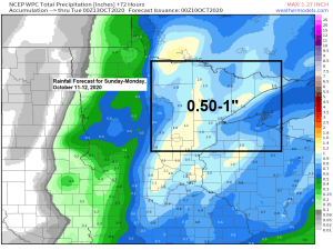
A strong area of low pressure will move into Manitoba on Sunday while a warm front and cold front and upper level trough move east out of the Northern Plains. This system will bring about a 3 to 6 hour window of rain to northeast Minnesota and northwest Wisconsin sometime from Sunday evening into early Monday morning with rainfall amounts of a half to one inch looking likely in our area.
Note: There is a chance for a few strong to severe thunderstorms late Sunday afternoon or Sunday evening mainly over parts of west-central and southwest Minnesota, far eastern South Dakota and southeast North Dakota, but severe weather is not expected to impact the Northland Sunday night, although a few embedded thunderstorms can’t be ruled out with the rainfall Sunday night as there will be some elevated CAPE and rather steep mid level lapse rates moving across the area.

Pretty good model agreement for next week regarding the temperature forecast.
Looks quite a bit cooler next week, especially later in the week, this is when daytime highs might struggle to get out of the 30s and low 40s across the Northland.
Source: https://weathermodels.com/

Source: https://www.tropicaltidbits.com/

To go along with the colder weather late next week, it also looks like we could see some snow showers or mixed showers across parts of the Northland about a week from today.
Shown below is the 12z European ensemble model 50 member snowfall matrix ending on October 23rd, 2020 – 84% of the EPS ensemble members show at least 0.1″ snowfall occurring in Duluth after October 15th. Amounts and dates of when we may see some snow vary between the individual members, but the main takeaway from all this is that chances we see at least a little snow in Duluth before Halloween are increasing, but keep in mind Duluth averages 2.3″ of snow during the month of October.
Source: https://weathermodels.com/

Thanks for reading!
Tim
Leave a Reply