A widespread rain event is on the way tonight into Monday morning. For Duluth, this will likely be our greatest rain event we’ve seen in over a month!
Rain will begin in western parts of the area this evening, mainly after 7 PM. Then will see the rain spread farther to the E-NE overnight. Rain will come to an end from SW-NE Monday morning, but could linger into early Monday afternoon over the tip of the Minnesota Arrowhead (Hovland and Grand Marais areas)
Note: Rain is expected to reach Duluth and Superior between Midnight and 2 AM tonight with rain then persisting until around 8-9 AM Monday before ending.
Skies will clear across the Northland by Monday afternoon but it will be a windy day as west to northwest winds increase to 15 to 30 mph. Highs on Monday will range from around 50 to 60 degrees across the Northland.
18z NAM 3km radar forecast ending 3 PM Monday.
Source: https://weathermodels.com/

Still looking at widespread half to one inch rainfall totals across the Northland tonight into Monday morning, and there could be some localized higher amounts approaching 1.25″.
Source: https://lab.weathermodels.com/

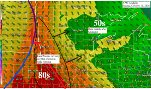
There is an isolated severe thunderstorm threat mainly before Midnight over western portions of the Northland, roughly west of a line from Orr to Pine City (dark green area on map)
A somewhat greater chance for a few severe thunderstorms exists across west-central and southern Minnesota for tonight (yellow area on map)
Damaging winds and hail are the main threats with a few of the storms this evening.

You have to go back to September 1st, or 39 days ago to find the last time Duluth picked up at least a quarter inch of rain (0.27″ on September 1st)
Source: https://mesonet.agron.iastate.edu/

Tonight’s system does have a decent amount of moisture with a corridor of 50 to 60 degree dew points pushing NE out of the eastern Dakotas and western/southern Minnesota this afternoon. A strong low level jet out of the south at speeds of 40 to 60 knots will help advect this richer moisture into the Northland tonight.

A strong upper level trough is moving into the Northern Plains this afternoon and will eventually pass over the upper Midwest tonight. Forcing associated with this trough will cause widespread rain to break out across the region tonight.

Here’s a look at the system which will affect the Northland tonight on Goes-16 water vapor imagery. It’s currently affecting the Rockies and Northern Plains this afternoon and is east bound.
Note: Loop time ends at 2:26 PM, Sunday, October 11, 2020.
Source: https://weather.cod.edu/

There’s been some snow today across parts of the Rockies (blue colors on map)
Note: We may see a little snow in parts of the Northland late this week/next weekend, but at the moment it doesn’t look like it would be anything too significant, mostly just flurries.

Another low pressure system could affect the Northland on Wednesday but there are some differences on the track of the low with a few models digging the low further S/SE, while other models keep the low farther north.
This system could bring another round of rain to northeast Minnesota and northwest Wisconsin on Wednesday, and if the low digs further south it may pull in enough cold air to produce a rain/snow mix in some parts of the area. Stay tuned.

October 11, 2020 – Still some fall color showing up along the hill in Duluth, Minnesota as viewed from the Billings Park area (Superior, Wisconsin) Sunday morning.

Thanks for reading!
Tim
Leave a Reply