A strong area of low pressure will move quickly east across the upper Midwest on Wednesday. This system will bring another round of rain to much of the Northland on Wednesday with the most persistent rain expected to setup across northern Minnesota, mainly north of Duluth. Occasional rain showers are likely further south on Wednesday, including for east-central Minnesota, Twin Ports and northwest Wisconsin.
Colder air wrapping into this system could cause the rain to mix with snow during the day Wednesday, but more likely Wednesday evening across portions of north-central and northeast Minnesota, but no snow accumulation is expected.

Rain will spread east reaching the Northland early Wednesday morning (~4-8 AM time frame) Rain will then continue throughout the day, most persistent across the north, while further south we should see the rain become more scattered with some breaks in the rain likely across east-central Minnesota and northwest Wisconsin late Wednesday morning through Wednesday afternoon.
Rain could become mixed with snow Wednesday night across parts of north-central and northeast Minnesota (blue colors on map)
Precipitation is expected to diminish from NW-SE later Wednesday night/early Thursday morning.
18z NAM 3km radar forecast valid from 1 AM tonight to 7 AM Thursday.
Source: https://weathermodels.com/

Rainfall amounts ranging from a half to three quarters of an inch (locally higher amounts) are expected across northern Minnesota on Wednesday, while further south around a tenth to quarter inch of rain is possible.
Source: https://lab.weathermodels.com/

Check out how low the 500mb heights have gotten across northern Canada, down to 516 decameters this afternoon, a sure sign that winter is fast approaching!
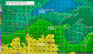
A much colder air mass off to our northwest today will make its way into the Northland over the next few days with highs Thursday and Friday only in the 30s and lower 40s in northeast Minnesota and northwest Wisconsin. Also looks like will have some scattered snow and rain showers around the area later this week.

A powerful jet stream with winds up to 160 knots is blasting into the Pacific northwest today as an active storm track has setup across the northern tier of the U.S.
System which moved through the Northland earlier today continues to move quickly to the ENE this afternoon, while the next system heads this way out of southwest Canada and the Pacific northwest.
Water vapor loop from Tuesday, October 13, 2020.
Source: https://weather.cod.edu/

Computer models are showing the potential for an accumulating snow event across parts of the Northland this weekend, but models disagree with the track of a low pressure system. At the moment it looks like the greatest chance for some snow would be west/north of Duluth on Saturday, but there is a chance that higher elevated areas inland from Lake Superior in Duluth sees some snow on Saturday. Note: Temperatures should be warm enough closer to Lake Superior for precipitation to fall as rain on Saturday the way it looks now.

Here’s my preliminary forecast for Saturday.
Not putting out any snow amounts yet because of the different storm tracks the computer models are showing.

Thanks for reading!
Tim
Leave a Reply