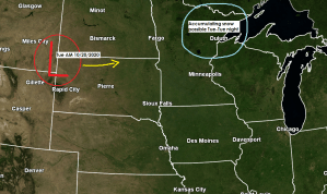
Our second widespread snow event of the 2020-2021 snow season could hit the Northland on Tuesday.
An even colder air mass should be in place for Tuesday’s system as 850mb temperatures range from around -3 to -7C, while 925mb temperatures range from around -2 to -3C. Surface temps are forecast to range from around 31 to 34 degrees on Tuesday. So it certainly looks cold enough right now for snow to be the main precipitation type on Tuesday.
As for timing – At the moment it looks like most of the snow would fall from late morning Tuesday thru Tuesday evening, tapering off late Tuesday night. The snow will spread from SW-NE across our area on Tuesday.
Note: Snow is forecast to reach Duluth and Superior around 11 AM to 1 PM Tuesday with snow then continuing thru Tuesday evening before ending late Tuesday night (timing could change a bit over the next few days)
Based on projected precipitation amounts and snow to liquid ratios which look to be in the 6:1 to 8:1 range per model data, here’s what I have come up with for snowfall totals on Tuesday.
2 to 5 inches across east-central Minnesota, northwest Wisconsin and along the North Shore of Lake Superior including Duluth and Superior.
1 to 2 inches further north including the Iron Range and Borderland areas.
Note: Amounts and gradients could change over the next few days.

Computer models are showing another system for later in the week, but there is more uncertainty on the storm track and where the rain-snow line sets up with this one.
The GFS, Canadian and UK models keep this system further south with more of the Northland in the cold air with a possibility for another accumulating snow event late this week, but the Euro model continues to be more to the NW with the track of the low which pulls warmer air into most of the Northland which leads to more rain than snow for most of the Northland, except from around Walker to I-Falls.
Note: If the European model is correct, then we could even see a few thunderstorms on Thursday over east-central Minnesota and northern Wisconsin.

Normal highs in mid-October are in the lower 50s, but temperatures this afternoon have been holding in the upper 20s to middle 30s across the Northland.
It won’t be any warmer Monday as highs will only be in the 30s once again.

Thanks for reading!
Tim

Leave a Reply