Not even into November yet and here we are looking at our second snow event this season worthy of a winter weather advisory, this one is for Tuesday afternoon into Tuesday night.
Temperatures aloft continue to look cold enough to support snow once precipitation arrives on Tuesday, but surface temperatures especially within about 5 miles of Lake Superior may warm enough prior to when precipitation starts to fall where we could see rain or a mix before things go over to snow, but everywhere else it looks cold enough from surface to aloft for snow thru the duration of this event.
Speaking of temperatures they look to be in the 30 to 34 degree range on Tuesday, but may get as warm as 35 to 38 degrees closer to Lake Superior as east winds bring in slightly warmer temps off the lake, but even close to Lake Superior we should see temps fall to around 33 to 34 degrees once precipitation moves in mid to late Tuesday afternoon.
Snow that falls on Tuesday will be wet and slushy due to temperatures which will be near or a little above freezing, this will also impact snow to liquid ratios. Typically we see SLR’s of around 10:1 to 15:1 in our area, but these early season snowfalls with the milder temps typically have ratios <10:1. With Tuesday’s event we’re looking at ratios somewhere in the 5:1 to 8:1 range depending on which forecast model you want to believe.
As for wind on Tuesday – nothing too significant expected, generally 5 to 15 mph with gusts to around 20 mph out of the east or southeast
Note: There is a chance for some scattered snow showers and flurries over east-central Minnesota and northwest Wisconsin tonight with accumulations of a coating to an inch possible in a few spots.
Some lake effect snow showers could impact areas near Lake Mille Lacs tonight with a cold southerly flow in place, and then as winds shift ESE on Tuesday some lake effect snow showers will be possible along the North Shore of Lake Superior.
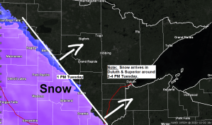
A winter weather advisory is in effect for much of the Northland for Tuesday afternoon into Tuesday night (purple shaded area on map)
Plan on slippery road conditions which could impact the Tuesday evening commute.
Note: The advisory for Duluth and Superior is in effect from 1 PM Tuesday to 1 AM Wednesday.
Source: https://www.weather.gov/dlh/

Timing Tuesday’s snowfall – Note there has been a bit of a slowing trend to when the snow will start falling in our area on Tuesday.
Snow is expected to spread from southwest to northeast across the Northland on Tuesday, starting first in the Brainerd Lakes area in the 10 AM to 1 PM time frame.
Snow is then expected to reach a line from Bigfork to Duluth to Ashland between 2 PM and 4 PM Tuesday.
Snow reaches the Borderland and Arrowhead areas between 5 PM and 8 PM Tuesday.
Snow is expected to end from SW-NE late Tuesday night or Wednesday morning.
18z NAM 3km radar forecast valid from 7 AM Tuesday to 7 AM Wednesday.
Source: https://weathermodels.com/

My updated snowfall forecast for Tuesday’s event.
Highest totals in the 3 to 5 inch range affecting east-central Minnesota, all of northwest Wisconsin and along the North Shore of Lake Superior including Brainerd, Aitkin, Hinckley, Moose Lake, Cloquet, Two Harbors, Silver Bay, Grand Marais, Washburn, Bayfield, Ashland, Hurley, Siren, Spooner, Shell Lake, Solon Springs, Minong, Hayward and Winter.
Snowfall of 2 to 3 inches further north including Bigfork, Hibbing and Ely, tapering off to around a trace to 2 inches for the International Falls area.

Snowfall forecast for Tuesday zoomed in on the Twin Ports.
Highest amounts of 3-5″ on top of the hill with lesser amounts of 1-3″ below the hill in lower elevation, and there may also be a rain/snow mix at times close to Lake Superior Tuesday afternoon.
Plan on slippery road conditions in the Twin Ports by late Tuesday afternoon continuing into Tuesday night.

Winter Storm Severity Index for Tuesday, October 20, 2020.
Generally minor impacts are expected with Tuesday’s snowfall across northeast Minnesota and northwest Wisconsin.
Source: https://www.wpc.ncep.noaa.gov/

The pattern is locked and loaded as a large upper level low spins to our north across central Canada while low pressure systems pass west/south of that upper low to our north. It’s a very active storm track across the northern tier of the US, a classic La Nina signature.
Water vapor loop from Monday, October 19, 2020.
Source: https://weather.cod.edu/

I’m keeping an eye on a system for later this week as it may pack quite a punch, but there continues to be differences on the storm track, and also on where the rain-snow line sets up.
Certainly looks like another advisory level system, and possibly even winter storm warning type snowfall for parts of the Northland later this week.
Wind could also be an issue with the system late this week with northeast gales possible near Lake Superior on Thursday.
At the moment the greatest chances for snow continue to be NW of Duluth on Thursday, but it is close, any shift to the SE with the low would bring that snow further southeast, but as it stands now it looks like north-central Minnesota is most likely to see some snow on Thursday while rain and maybe even a few thunderstorms occur across east-central Minnesota and northwest Wisconsin as elevated CAPE and steep lapse rates lift NE ahead of this system.
Stay tuned

Thursday’s system looks to have that classic temperature gradient with cold air NW of the low while warm air surges NE out ahead of the low.
Source: 12z European ensemble model 10.19.2020; https://weathermodels.com/

Thanks for reading!
Tim
Leave a Reply