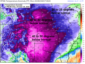
Deep freeze! Temperatures this Monday afternoon, October 26th, 2020 are running 30 to 50 degrees below normal across the central US.
Freezing line all the way south to north-central Arizona, southern New Mexico into west-central Texas here in late October, while temperatures are only in the 10s this afternoon across parts of the Rockies and Western High Plains. An impressive cold shot for so early in the season.
Note: The last time the Duluth Airport was above freezing was last Friday afternoon ~5PM, October 23rd, we’ve been below freezing ever since, but this streak might end Tuesday afternoon, but more likely on Wednesday as temperatures finally climb above the freezing mark at the Duluth Airport.

No doubt about it it’s been a cold October around here, with 16/25 days or 64% of days this month having a below average temperature, while just 9/25 days or 36% of days having an above average temperature.
Source: https://mesonet.agron.iastate.edu/

Average Temperature and their departure from normal for October 2020 (thru the 25th) plus the coldest Octobers on record at select climate stations across the Northland
International Falls, MN: 35.6 degrees; -6.7 degrees below normal (coldest October on record 32.7 degrees set in 1917) Note: October 2020 currently ranks as the 5th coldest October on record at International Falls.
Hibbing, MN: 35.8 degrees; -6.1 degrees below normal (coldest October on record 33.6 degrees set in 2002) Note: October 2020 currently ranks as 2nd coldest October on record at Hibbing.
Duluth, MN: 40.2 degrees; -4.2 degrees below normal (coldest October on record 33.5 degrees set in 1917)
Ashland, WI: 41.1 degrees; -4.6 degrees below normal (coldest October on record 36.1 degrees set in 1917)
Brainerd, MN: 41.3 degrees; -5.4 degrees below normal (coldest October on record 32.6 degrees set in 1925)
Here’s a look at the temperature anomaly for October 2020 (thru the 25th)
Source: https://lab.weathermodels.com/

| Record Cold Temperatures across the Northland over the past few days Hibbing, Minnesota Record lowest maximum temperature set for October 25th with a high on Sunday of 27 degrees, this breaks the previous record for the date of 28 degrees which was set 1942 and tied in 1981. Also, on October 24th, a record lowest maximum temperature of 29 degrees was set at Hibbing, this broke the previous record for the date of 30 degrees set in 1981. A record low temperature of 11 degrees was set on October 24th, this broke the previous record of 17 degrees which was set in 1981. Brainerd, Minnesota Record lowest maximum temperature set for October 25th with a high on Sunday of 29 degrees, this breaks the previous record for the date of 30 degrees which was set in 1919 and tied in 1942 and 1997. Duluth, Minnesota Record lowest maximum temperature tied for October 25th with a high on Sunday of 27 degrees, this ties the previous record for the date which was set in 1919. Ashland, Wisconsin Record lowest maximum temperature tied for October 25th with a high on Sunday of 32 degrees, this ties the previous record for the date which was set in 1942. |
…Weather Summary for the Northland…
Cold and dry for now, followed by milder temps and continued dry conditions midweek into next week.
Will have a few low pressure systems with their warm fronts and cold fronts sweep through the Northland this week, but little if any measurable precipitation is expected, with only a few light showers of rain or snow across northern Minnesota late Tuesday-early Wednesday, and possibly a few snow showers across parts of the Northland on Thursday.
Lows in the single digits to around 20 degrees tonight, highs Tuesday in the 30s, but on Wednesday will get a brief spike in temps with upper 30s to mid 40s across the area. Will cool down briefly on Thursday, with highs mainly in the 30s.
Note: It does look like will have a few days near or above 50 degrees across the Northland between October 31st-November 7th, and it doesn’t look like will be seeing a whole of precipitation at least thru the first week of November, but after that things may begin to change…
An ice storm is hitting parts of central Oklahoma today (pink/orange colors on map) and there’s even been some snow in parts of northern Arizona today!

Periods of freezing rain, sleet and snow will continue into Wednesday morning across parts of the Southern Plains.
Ice in purple, rain in green, snow in blue on the animation below.
18z NAM 3km radar forecast thru 7 AM Wednesday.
Source: https://weathermodels.com/

A corridor of significant ice accumulations are possible over the next 24 to 36 hours from north-central Texas into central Oklahoma and south-central Kansas with a quarter to half inch of ice accretion possible, and this is on top of the ice they have received today.
Source: https://lab.weathermodels.com/

A lot of snow on the way as well with the storm early this week centered on New Mexico.

Ice storm warnings, winter storm warnings, hurricane watches and tropical storm watches, just a typical day in 2020.
Source: https://home.pivotalweather.com/

Hurricane Zeta is expected to make landfall somewhere in southern-southeastern Louisiana Wednesday evening/early Thursday morning. After that Zeta becomes extratropical while it possibly brings some snow and strong winds to parts of the northeast US on Friday.
Zeta has winds of 80 mph as of 4 PM Monday, October 26, 2020, and some slight strengthening is possible per NHC forecasts.

Thanks for reading!
Tim
Leave a Reply