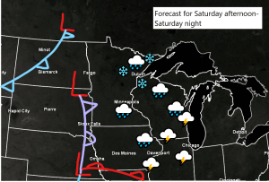
Tonight and most of Saturday morning look dry across the Northland, but chances for some rain, snow and possibly some patchy sleet will increase as we go through Saturday afternoon and into Saturday evening, and the chances for precipitation will linger right into Sunday morning.
A few areas of low pressure are forecast to move east/southeast out of the Northern Plains on Saturday, while another low passes north of our area across Manitoba and into Ontario. A southern low will become more dominant as it tracks from eastern Iowa to eastern Lake Superior from Saturday night into Sunday morning while deepening to around 985mb. So although some precipitation is likely to fall across northeast Minnesota and northwest Wisconsin from Saturday afternoon into Sunday morning, it doesn’t look like it will be very heavy, as the better moisture/heavier precipitation sets up farther south/east and away from our area.
Goes-16 water vapor loop for Friday, November 13, 2020 shows our weekend system digging south/east out of western Canada and the Pacific northwest this afternoon.
Source: https://www.star.nesdis.noaa.gov/

This weekend’s system is a strong one as it will consist of a couple areas of low pressure phasing together, but not until it passes well east of the Northland where a closed off 500mb low develops on Sunday.
Source: 12z NAM 500mb vorticity forecast valid 12 PM Saturday to 6 PM Sunday; https://www.tropicaltidbits.com/

Note: Any precipitation we see Saturday afternoon into early Saturday evening could come in the form of rain or patchy sleet as temperatures warm into the mid 30s to around 40 degrees in northeast Minnesota and northwest Wisconsin, but come Saturday evening will see thickness values drop to around 540, while temps at the surface and aloft become cold enough to produce a bit of snow, or perhaps a rain/snow mix in parts of northwest Wisconsin, and also closer to Lake Superior.
Scattered flurries and snow showers could linger into most of Sunday morning followed by mainly dry weather Sunday afternoon with highs in the 30s.
18z NAM 3km radar forecast valid from 12 PM Saturday to 12 PM Sunday.
Source: https://weathermodels.com/

Here is my snowfall forecast for Saturday evening thru Sunday morning. Overall nothing too significant, with snow totals generally ranging from a trace to 2 inches, with those higher totals mostly northeast and east of Duluth the way it looks now.

Thanks for reading!
Tim
Leave a Reply