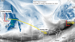
System which will affect the Northland late Saturday night-Sunday morning is moving into British Columbia this afternoon, and this system will move quickly to the ESE over the weekend.
Source: https://www.star.nesdis.noaa.gov/

A quick moving system digs SE through the northern Plains and upper Midwest late Saturday into Sunday morning, as this system moves over the Northland it will increase the lift in the atmosphere which will lead to a period of snow or possibly a wintry mix in parts of the Northland late Saturday night into Sunday morning.
500mb vorticity forecast valid from 12 PM Saturday to 12 PM Sunday per 18z NAM model.
Source: https://weather.cod.edu/

Snow or a wintry mix is forecast to move SW to NE across parts of the Northland late Saturday night into Sunday morning, beginning first in the Brainerd Lakes area after Midnight, then spreading NE thereafter. Snow or mixed precipitation will end from SW-NE by late Sunday morning/Sunday afternoon.
Note: Timing for when we could see some snow or a mix in Duluth and Superior looks to be from around 6 AM to Noon Sunday.
18z NAM 3km radar forecast valid from 10 PM Saturday to 4 PM Sunday.
Source: https://weathermodels.com/

We’re not looking at a whole lot of snow with Sunday’s system, with generally around 1 to possibly as much as 3 inches of accumulation the way it looks now. The quick movement of this system is one reason why we won’t get a whole lot of snow, as it looks like the snow will only last a few hours at most.
Note: Highest amounts of snow still look to be west of Duluth.
Temperatures will be on the mild side Sunday morning, generally around 30-33 degrees so this probably will be a wet snowfall, and with temps near or slightly above 0C at 925mb this could even lead to a snow/rain mix in some parts of the area especially if precipitation is on the light side, but if we get bursts of heavier precipitation (which is possible given steep mid level lapse rates >7.0 c/km) then the atmosphere should cool enough for mostly snow Sunday morning.

Goes-16 Day Cloud Phase loop from Friday, November 20, 2020 shows the widespread low clouds (shown in red) which covered much of the Northland today, although some breaks in the overcast has occurred this afternoon over portions of east-central Minnesota (black areas on loop) while more widespread clearing was found across southern Minnesota late this afternoon.
Overall today, Friday, was a very typical November day around here with gray skies and a brisk feel, although actual highs were very close to normal for the 20th of November, with highs today in the upper 20s to middle 30s.
Source: https://www.star.nesdis.noaa.gov/

There is another system which has been showing up on model guidance for a few days now, and this one could impact our area around next Tuesday bringing accumulating snow or possibly a rain/snow mix to northeast Minnesota and northwest Wisconsin, this doesn’t look like it will be a major storm, but a few inches of slushy snowfall is possible across parts of the Northland next Tuesday. Stay tuned.

Thanks for reading!
Tim
Leave a Reply