A mixture of precipitation types ranging from snow to rain to sleet and possibly even a bit of freezing rain is expected to move quickly through northeast Minnesota and northwest Wisconsin later this evening into early Friday morning. Although precipitation amounts should remain light tonight, there could be enough snow/sleet to cause some slippery travel conditions later tonight into early Friday morning. Note: A wintry mix is possible in Duluth and Superior around Midnight to 2 AM tonight, which could be followed by a few snow showers during the day Friday.
18z NAM 3km model radar forecast thru Noon Friday.
Source: https://weathermodels.com/

Snowfall accumulations of up to an inch are possible tonight across far northern Minnesota. Little to no snow accumulation is expected farther south.

Tonight’s system is fairly strong as it heads east out of southern Saskatchewan, but most of the energy will stay well north of our area, so we’re only looking at a brief period of snow, rain, sleet or freezing rain across the Northland later this evening and into early Friday morning.
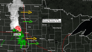
Source: https://weather.cod.edu/

Quite a bit going on on this visible satellite image from late Thursday morning.
- A widespread area of low clouds stretching from North Dakota to northern Minnesota.
- An area of Accas (mid level clouds) across northeast Minnesota to Lake Superior associated with a plume of steep mid level lapse rates, similar to what you’d see on a summer day.
- Finally, some snow cover across central Minnesota.
Source: https://www.star.nesdis.noaa.gov/

And here’s a visible satellite loop from Thursday, November 19, 2020 – loop time ~11 AM to ~4 PM.

Note: November 2020 (as of the 18th) ranks as the 4th warmest November on record at International Falls, and the 5th warmest November on record at Duluth. Will see where November 2020 will end up, but there’s a pretty good chance it will remain in the top 5 warmest. Just last month, Duluth and International Falls had a top 5 coldest October on record.
Can’t beat these temperatures on a mid-November day. Widespread 40s late this afternoon across east-central Minnesota and northwest Wisconsin, with 30s across northern Minnesota, but there is some cooler air farther northwest where temps were in the mid 20s to around 30 degrees late today, and this cooler air will make its way into the Northland over the next few days, but this will just mean temps closer to normal for this time of year instead of temps some 10-15 degrees above normal!

Arctic air is out there, but remains well to our northwest and shows no signs it will make a move into the upper Midwest for the rest of this month, and possibly even through early December.
Check out a few of these temperatures from Thursday afternoon (white outlined area on map)
- Dawson -35 F
- Northway Airport -23 F
- Fort Yukon Airport -22 F
- Faro Airport -20 F
- Old Crow Airport -20 F
- Fairbanks -13 F

Arctic air masses will have a tough time pushing very far to the south when you have a jet stream screaming in off the Pacific.

There is another system which could affect the Northland in the late Saturday night to Sunday time frame, this one could bring a little more snow to the area, with potential for 1 to 3 inches of snow accumulation across north-central, east-central and northeast Minnesota into far northwest Wisconsin.

Thanks for reading!
Tim
Leave a Reply