We have three shots for some precipitation over the next few days. The first chance comes Thursday morning when we could see a few rain showers mainly across northern Minnesota, and then will see another chance for some showers across most of the Northland Thursday night, and these showers could be in the form of rain, sleet or snow. The final chance for some precip comes late Saturday night into Sunday, and most of this should be in the form of snow the way it looks now. Note: None of these precipitation events look to be very impactful, with mostly light amounts of rain or snow expected the way it looks now, however, there is a system showing up on model guidance next week (Tuesday/Wednesday time frame) that could be a little more interesting in terms of snowfall, stay tuned.
500mb vertical velocity forecast thru early Sunday morning per 18z NAM model. Note: The yellow, orange and red colors represent times of stronger atmospheric lift/better chances for some precipitation to occur.
Source: https://weather.cod.edu/

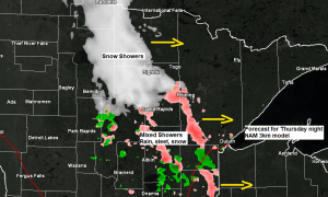
Here’s the 18z NAM 3km model radar forecast valid from 6 AM Thursday to 7 AM Friday.
Source: https://weathermodels.com/

All the cold arctic air remains bottled up across northwest Canada into parts of Alaska where its bitterly cold. Temperatures this Wednesday morning were in the -30s below zero in Dawson, with widespread -10s and -20s in Alaska. No signs will see this arctic air push SE into the US anytime soon with prevailing upper level winds coming out of the west or southwest which helps keep the arctic air well to our NW.

An upper level ridge to our SE is leading to a surge of milder temperatures across the upper Midwest today thanks to upper level winds which are coming out of the southwest.
Here’s a water vapor loop from today, Wednesday, November 18, 2020.
Source: https://weather.cod.edu/

All the cold stuff is focused over eastern Canada into the northeast US today, and also over western Canada.
This week’s upper level ridge isn’t quite as potent as the one we saw earlier in the month, but we are still seeing some fairly impressive (high) 500mb heights across the region today, with the 570 decameter line reaching into southern Minnesota today.

Temperatures this Wednesday afternoon were in the 60s and 70s across parts of South Dakota, with 50s in southern Minnesota, and upper 30s/lower 40s across northeast Minnesota and northwest Wisconsin.
Note: Highs on Thursday will range from the middle 30s in far northeast Minnesota to the 40s and lower 50s across north-central and east-central Minnesota and northwest Wisconsin, this is anywhere from 5 to as much as 15 degrees above normal for mid-November.
Note: High of 41 degrees at the Duluth Airport today, Wednesday November 18, 2020 – Warmest temperature in Duluth since November 9 when it was 65 degrees.

Thanks for reading!
Tim
Leave a Reply