18.2″ of snow so far this month at Duluth, Minnesota. Normal snowfall for November is 13.7″. Although November 2020 has featured above normal snowfall in Duluth, will still need an additional 7.5″ of snow the rest of this month to get into the top 10 snowiest Novembers on record list, and chances of that happening aren’t looking very good.
Snowfall reports from around the Northland for Sunday, November 22, 2020.
Source: https://www.weather.gov/dlh/
- Pequot Lakes, MN: 3.0″
- 5 SSE Libby, MN: 2.7″
- 1 W Buyck, MN: 2.0″
- Wrenshall, MN: 2.0″
- McGregor, MN: 2.0″
- 3 NNW Mahtowa, MN: 1.7″
- 1 N Cloquet, MN: 1.7″
- 2 SSW Moose Lake, MN: 1.5″
- 1 ESE Nisswa, MN: 1.5″
- Duluth Airport: 1.5″
- Kettle River, MN: 1.3″
- 3 N Brainerd, MN: 1.3″
- Gary New Duluth, MN: 1.0″
- Longville, MN: 1.0″
- International Falls, MN: 0.6″
A couple snow pics from Duluth, Minnesota from today, Sunday, November 22, 2020.


We’ve had nearly as many days above average (11) compared to number of days below average (10) so far this month in Duluth, yet November 2020 is running nearly +5.0 degrees warmer than average, mostly because of how warm it was during the first week of this month.
The chart below shows daily average temperature departures for November 2020. Red=Days above average; Blue=Days below average.
Source: https://mesonet.agron.iastate.edu/

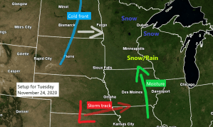
Our next system to keep an eye on is moving ashore in the Pacific northwest this afternoon and will dig ESE over the Rockies on Monday before ejecting east into the Midwest and to the eastern Great Lakes from Tuesday through Thursday.
Source: 12z Euro ensemble model 11.22.2020; https://weathermodels.com/

Water vapor loop from today shows a fairly active but a progressive weather pattern with three notable systems.
- Low pressure over northeast Ohio.
- Trough moving out of the upper Midwest and into the western Great Lakes.
- Low pressure/trough moving into the northwest US.

Troughs (blue) Ridge (red)

Tuesday’s system doesn’t look like a big snow maker for our area, but we could see widespread 1 to 2 inch amounts which could lead to hazardous travel conditions across northeast Minnesota and northwest Wisconsin.
Note: There is a chance for some lake/orographic enhanced snowfall along the North Shore on Tuesday as winds will be out of the east-southeast, this could help in boosting snow totals more into the 2-4 or even 3-5 inch range along the North Shore. Stay tuned.

Snow is forecast to reach the Brainerd Lakes area around 4-6 AM Tuesday, and then will see some snow spread farther north/east through the day Tuesday. Snow comes to an end from SW-NE Tuesday night.
Note: Snow moves into Duluth and Superior around 8-10 AM Tuesday the way it looks now.
18z NAM 3km model simulated radar forecast valid from 1 AM Tuesday to Midnight Wednesday.
Source: https://weathermodels.com/

Thanks for reading!
Tim
Leave a Reply