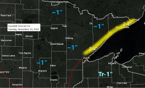
- Snowfall totals of around an inch are expected on Tuesday for most of northeast and east-central Minnesota, with trace to 1″ amounts for northwest Wisconsin. Note: Higher snowfall totals of 2 to 4 inches are possible along the North Shore due to some lake/orographic enhanced snowfall as winds will be coming off Lake Superior (east-southeast)
- Areas of fog, drizzle and freezing drizzle are also possible across the Northland on Tuesday, with a light glaze of ice accretion possible in spots.
One would think we could be in trouble in the Northland after seeing the water vapor loop from today (Monday) as a strong trough makes its way across the Rockies while a plume of moisture (subtropical jet) surges NE out of the Baja region and into the Southern/Central Plains. This has all the makings of turning into a significant winter storm for the Northland, right? Nope, not this time. The brunt of the moisture with this system will pass well to our south while low pressure tracks ENE out of Kansas, with this low also staying well south of our area on Tuesday and Wednesday. The Northland will instead be impacted by a weaker northern stream wave/cold front on Tuesday with mostly light precipitation.
Source: https://weather.cod.edu/

An overcast morning in the Twin Ports turned into a nice afternoon with abundant sunshine as the low clouds earlier in the day lifted farther north mostly affecting the North Shore this afternoon, but look to the south as clouds are streaming north and will soon overtake the Northland once again by later tonight.
Note: Loop time 11:16 AM to 4:11 PM Monday, November 23, 2020.
Source: https://www.star.nesdis.noaa.gov/


Will see some snow and a mix of precipitation types (snow, freezing drizzle and drizzle) spread SW-NE through the Northland on Tuesday.
Precipitation begins in western areas after Midnight tonight and will spread farther ENE through the day Tuesday before ending from W-E Tuesday night.
Note: Some snow is likely at times on Tuesday in Duluth and Superior with precipitation moving into the Twin Ports ~6 AM to 9 AM Tuesday. There is a chance we could see the snow mix with or change to drizzle/freezing drizzle by Tuesday afternoon as surface temps warm to around 32-35 degrees. Areas of fog are also possible on Tuesday. Snowfall totals of around an inch are expected in Duluth and Superior on Tuesday with higher amounts possible on top of the hill (2-3″?)
18z HRRR model simulated radar forecast valid from Midnight tonight to Midnight tomorrow night.
Blue – Snow
Pink – Wintry mix
Green – Rain
Source: https://weathermodels.com/

Pattern for next week looks to become increasingly amplified, with both GFS and European computer models (12z run from Monday) showing a very strong ridge developing over the Northern Rockies or west-central Canada, while a strong upper level low (possibly a cutoff low) develops somewhere from the Midwest to the Southern Plains.
Note: At the moment it doesn’t look like the upper Midwest would be affected by the upper low to the south, so our weather would be influenced more by that massive ridge to our NW which may lead to a prolonged period of dry weather and relatively mild temperatures during the first week or so of December.


Source: https://weathermodels.com/

Temperature forecast for next week doesn’t resemble what a typical La Nina pattern would look like, it’s flipped upside down or something.
Source: https://weathermodels.com/

Thanks for reading!
Tim
Leave a Reply