- A generally quiet weather pattern continues across the Northland this week and probably into next week as well, although there are some signs showing up in model guidance that the pattern will start to turn a little more active around here starting around mid-December, but that is still a ways down the road, and whether or not mother nature flips the switch remains to be seen.
- Temperatures across northeast Minnesota and northwest Wisconsin will be a little cooler the next few days, but really just closer to normal for this time of the year. Note: Normal highs this week are generally in the mid to upper 20s, with normal lows in the single digits and teens.
- Milder temps look to return mid to late week, with highs in the 30s, and maybe even some 40s possible by next weekend (December 4-6 time frame)
It’s been a windy Sunday across the Northland, with a Wind Advisory in effect until 6 PM this Sunday evening for southern Cook County in northeastern Minnesota including the cities of Tofte, Lutsen, Grand Marais, Hovland and Grand Portage. Northwest winds around 15 mph with gusts to 45 mph will continue in the advisory area through early this Sunday evening.

| Wind Gusts from around the Northland for Sunday, November 29, 2020 Source: https://www.weather.gov/dlh/ Bay of Grand Marais: 55 mph Hibbing: 52 mph Grand Rapids: 41 mph Eveleth: 40 mph Duluth Airport: 40 mph Duluth Sky Harbor: 39 mph Superior: 39 mph Brainerd: 38 mph Walker: 37 mph Ashland: 35 mph Cloquet: 35 mph International Falls: 33 mph Two Harbors: 32 mph Ely: 32 mph Hill City: 30 mph Aitkin: 30 mph Hinckley: 30 mph Isabella: 30 mph Hayward: 30 mph |
It’s been a very dry year in the Twin Ports. Note: There is a pretty good chance that 2020 will finish in the top 10 for driest years on record at Duluth, Minnesota.
-Total precipitation in Duluth since September 1st: 6.08″; -2.85″ below normal (thru November 28)
-Total precipitation in Duluth since January 1st: 20.27″; -9.36″ below normal thru November 28)
-Snowfall, however, is running well above normal so far this season, with 31.2″ of snow in Duluth (thru November 28) this is +16.3″ above normal.
Some lake effect snow is likely tonight into early Monday afternoon along the South Shore of Lake Superior, with a Winter Weather Advisory in effect until Noon Monday for Iron County, including the cities of Upson, Gile and Hurley. Snowfall accumulations of 1 to 5 inches are possible in the advisory area. Gusty winds will also occur causing areas of blowing and drifting snow.
Note: Some lake effect snow could also impact portions of Ashland County tonight with accumulations of around 1 to 2 inches possible, especially over eastern parts of the county including the Mellen, Glidden and Butternut areas.

A bizarre looking weather pattern this week, with the main storm track staying well west/south/east of the Northland.
Shown below is the NAM model (12z run) 500mb height and vorticity forecast valid from 6 AM Monday to 6 PM Wednesday, November 30 to December 2, 2020.
Source: https://www.pivotalweather.com/

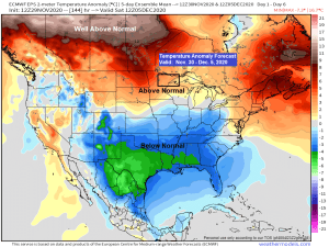
Trends for a warmer and drier than average December continue to show up per CFS model – Here’s the latest outlook for December 2020.
Note: This doesn’t mean we won’t get an occasional shot of cold air (possibly arctic air) but overall the pattern favors warmer than normal temps across the Northland in December.
Average temperature in Duluth in December is 14.8 degrees, while we typically get 10 days with a minimum temperature of 0 F or colder. Last December saw 9 days with a minimum temperature of 0 F or colder in Duluth, but the month was +2.6 degrees warmer than normal.
Source: https://www.tropicaltidbits.com/

Precipitation outlook for December 2020 per CFS model.
Note: Duluth averages 17.7″ of snow in December, but the forecast for December 2020 calls for below normal snowfall. Will see what happens.

Thanks for reading!
Tim
Leave a Reply