The pattern ahead looks pretty uneventful across the Northland, but we will have a few cold fronts/troughs pass through the area on occasion, with a chance for a few flurries/light snow showers, and possibly a little freezing drizzle, but no signs of any significant snow event impacting our area through the next 2 weeks.
Timing the cold fronts/troughs
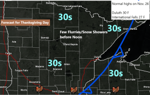
- Thanksgiving
- Friday morning
- Saturday night-Sunday morning
- Next Tuesday-Wednesday
Here’s the 500mb vorticity forecast from the 18z NAM model valid from 6 AM Thursday to 1 AM Sunday.
Source: https://weather.cod.edu/

November 2020 continues to run in the top 10 for warmest Novembers on record at all the major climate locations in the Northland, except at Duluth.
Here are the average temps for November 2020 (thru the 24th) and where they rank so far this month.
- Ashland: 38.0 F; 6th warmest
- Brainerd: 36.0 F; 9th warmest
- Duluth: 34.7 F; 11th warmest
- International Falls: 32.3 F; 9th warmest
- Hibbing: 31.0 F; 8th warmest
I think we’ve entered the gray period which is very typical weather for this time of the year, but hopefully will get enough mixing to occur to break up some of the clouds at times over the next few days, but overall I wouldn’t expect to see a whole lot of sun.
Source: https://www.star.nesdis.noaa.gov/

A strong area of low pressure continues to lift ENE across the Midwest and into the lower Great Lakes this afternoon per water vapor imagery.
Source: https://www.star.nesdis.noaa.gov/

There is a chance that a powerful winter storm will impact portions of the Ohio Valley and eastern Great Lakes region next week – Shown below is the 12z European model snowfall forecast for the November 30 to December 3 time frame.
Widespread 1 to 2 feet of snow (using a 10:1 ratio) across parts of Indiana, Ohio and Lower Michigan next week per Euro model. Wow!
Source: https://weathermodels.com/

Strange looking pattern still showing up in various computer models for next week, but it continues to look like the Northland will be dominated more by strong ridging to our NW forcing the storm track well south/east of our area.
500mb heights could be nearly as high across the Northern Rockies as they will be in south Florida by the end of next week (~582 meters) crazy stuff!
Source: https://www.pivotalweather.com/

Thanks for reading!
Tim
Leave a Reply