Daytime highs at or above freezing are expected to continue in Duluth through next Thursday. Note: Our normal high in Duluth in early December is around 25 degrees, but our highs will be at least 5 to 10 degrees above normal for the next week.
Source: NWS blend of models; https://weathermodels.com/

Latest CFS model weekly temperature forecast valid for mid to late December shows more of the same, and that’s well above normal temperatures continuing across northeast Minnesota and northwest Wisconsin, but this warmth covers the entire lower 48, not just the Northland. Note: All the cold air or sustained cold remains bottled up farther north across Canada and Alaska (green and blue colors on maps) per CFS model.
So although we may get a few shots of colder temps sprinkled in from mid to late December, it doesn’t look like it would stick around for very long.
Source: https://www.cpc.ncep.noaa.gov/


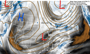
Pretty crazy to see the temperature at 850mb or ~5000 feet warmer in parts of Saskatchewan compared to Florida on this 3rd day of December 2020, but this is the case today.

A snowless or near snowless forecast continues into next week, with the GEFS ensemble model looking pretty dry across the Northland.
Here’s the 20 member 12z GEFS model snowfall forecast thru Thursday morning, December 10, 2020.
Some parts of the area might see a dusting to an inch of snow by next Thursday, but that looks to be about it.
Note: A snow event is possible somewhere across the upper Midwest/western Great Lakes sometime around December 11-14, but there is considerable uncertainty on the track/strength of any system during that time frame.
Source: https://weather.cod.edu/

Doesn’t look like will be seeing a whole lot of sun in the Northland Friday or Saturday if the HRRR model is correct.
Black areas=Clear sky
White areas=Clouds
Source: https://weather.cod.edu/

A mid level low dropping SSE out of western Ontario this weekend could go on to squeeze out a few flurries or snow showers in parts of the Northland from late Saturday into Sunday, but this shouldn’t be a big deal.
Shown below is the 18z NAM 500mb vertical velocity forecast valid from 6 AM Saturday to 6 AM Sunday.
Source: https://weather.cod.edu/

Thanks for reading!
Tim
Leave a Reply