A few disturbances will be dropping SSE across the Northland into early next week, with one such feature moving through the area on Saturday, followed by another for Sunday, and possibly one more Monday night. None of them look to produce more than some clouds and possibly a few snow flurries.
Model image – 18z NAM 500mb vorticity forecast valid 6 AM Saturday to Midnight Tuesday.
Source: https://www.tropicaltidbits.com/

Nothing close to normal expected in Duluth when it comes to temperatures through next weekend.
Normal highs in Duluth in early December are around 25 degrees while normal lows are in the low teens. No signs of any arctic air at least through December 14.
Note: For Duluth, December 2020 is running ~4 degrees warmer than average thru the 3rd.
Source: https://weathermodels.com/

A mix of clouds and sun across northeast Minnesota and northwest Wisconsin today, although most of the clouds seemed to be located closer to Lake Superior and also over far northern Minnesota, but a lot of the cloud cover eroded this afternoon, except in the tip of the Minnesota Arrowhead and along the South Shore of Lake Superior.
Note: Visible satellite loop from 12:36 PM to 4:31 PM CT, Friday, December 4, 2020.
Source: https://www.star.nesdis.noaa.gov/

Computer models have been hinting at a system possibly developing and impacting parts of the Northland sometime in the December 11-14 time frame, but there remains considerable uncertainty on timing, track and intensity of any system for next weekend, plus there isn’t really a whole lot of support in the ensemble guidance for a big winter storm next weekend, at least not yet, but I’ll be keeping a close eye on the computer models over the next several days to see if things change.
Could be dealing with two pieces of energy next weekend, one in the northern stream and another in the southern stream, whether or not they phase or remain separate won’t be known for days. A weaker northern wave would result in just some flurries or snow showers across the Northland next weekend, but if a southern wave develops and heads this way, then we could be talking about something more than a few inches of snow. Stay tuned.

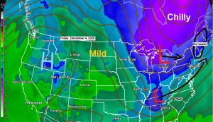
The big weather story this weekend will be a Nor’easter which will affect the northeast US Saturday into Sunday with wet heavy snow, rain and strong winds. This storm is starting to come together today, and consists of a northern stream disturbance digging SE across the Great Lakes, while another piece of energy heads ENE across the southeast US. Both pieces of energy will phase across the northeast US this weekend.
Note: Water vapor loop time 2:06 PM to 4:36 PM CT, Friday, December 4, 2020.

Winter Storm Warning (Pink)
Winter Storm Watch (Blue)
Winter Weather Advisory (Purple)
High Wind Warning (orange/tan/brown or whatever color that is)
Source: https://www.pivotalweather.com/

A pretty decent snowfall expected in parts of the northeast this weekend, with potential for 6 to 10″+ of wet heavy snow.
Source: https://www.pivotalweather.com/

Thanks for reading!
Tim
Leave a Reply