- The last time Duluth picked up at least an inch of snow was back on November 22 (1.6″)
- 31.2″ of snow so far this season at Duluth, Minnesota, this is +12.4″ above normal thru December 5. Last year’s snowfall total thru December 5 was 35.8″
Another mild week ahead in Duluth, with daytime highs forecasted to be above freezing through Friday, after that we could see some cooler air work in (at least closer to normal type stuff for a little while) but no signs of any subzero temps in Duluth through December 16. Note: On average, Duluth has 9 days with a minimum temperature <0 F in December, we’ve had zero so far this month.
Source: https://weathermodels.com/

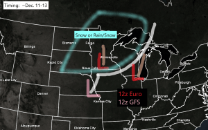
A low pressure system could impact the Northland bringing some snow or possibly a rain/snow mix to the area in the December 11-13 time frame.
There is still a great deal of uncertainty on how this system will play out, including differences on the storm track and intensity between the GFS and Euro computer models.
Both models have a similar 500mb pattern on Thursday, December 10, with two systems, one in the northern stream, the other in the southern stream (marked by a red L on the maps below)
Source: https://www.tropicaltidbits.com/


But by Saturday, the differences become quite large in the handling of the two lows, and whether or not they phase or remain separate.
The GFS model is all in on showing a rather strong winter storm impacting much of the Northland next weekend, with even a closed 500mb low developing over Iowa/southern Minnesota.
These differences lead to the GFS model showing a lot more snow (4-8″+) compared to the Euro solution (1-3″)

And then you have the European model showing a less phased/weaker system for next weekend.
Plenty of things for the models to work out over the next few days. Stay tuned.

14/20 or 70% of GEFS model members show at least 2″ of snow in Duluth in the December 11-13 time frame. But there are some members which keep next weekend’s system farther south/east of our area.
Shown below is the 12z GEFS model snowfall accumulation forecast ending 6 PM Sunday, December 13, 2020. Note the differences in snow totals in the 20 members, some show quite a bit, others not so much.
Source: https://weather.cod.edu/

One thing that shows no signs of changing are the warmer than average temperatures which look to continue through the rest of December, so although the pattern may start to crank up in terms of getting more frequent precipitation events to affect the Northland from mid to late month, it appears that arctic airmasses will be lacking, that doesn’t mean we won’t squeeze out a brief arctic dip, but chances of it lingering more than a day or two are quite low the way it looks now.
Shown below is the CFS model temperature anomaly forecast thru December 26, 2020.
Source: https://www.cpc.ncep.noaa.gov/


Thanks for reading!
Tim
Leave a Reply