- Several chances for snow through the middle of next week – Friday-Friday evening, Saturday night, Sunday night-Monday, and Tuesday-Wednesday
- The systems Sunday night-Monday, and Tuesday-Wednesday have the greatest potential of producing something more than 1-2″ of snow depending on the storm track.
Snow is forecast to begin in western portions of the Northland Friday morning after 6 AM, and then will spread farther northeast through Friday afternoon.
Note: Some snow is possible in Duluth and Superior from around 10 AM to 5 PM Friday, although the best chances look to be from around 2 PM to 4 PM Friday.
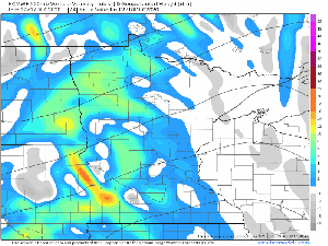
18z NAM 3km simulated radar forecast valid from 6 AM Friday to Midnight Saturday.
Source: https://weather.cod.edu/

A broad mid/upper level trough currently affecting the Rockies will move across the upper Midwest on Friday while a couple areas of low pressure move east as well, but this system will remain split meaning the lows won’t phase into one big low, instead will see a few weaker lows.
Water vapor loop from Thursday, December 17, 2020. Loop time 12:40 PM to 4:30 PM CT.
Source: https://www.star.nesdis.noaa.gov/

Friday’s system will have a little better forcing/lift (black outlined area on map) and a bit more moisture to work with compared to the last few systems which have moved through the area, but we’re still not looking at any major snow event by any means, but there likely will be enough snow accumulation in some parts of the area to cause some slippery travel conditions Friday into Friday evening.
18z NAM model 700mb vorticity forecast valid from 6 AM Friday to Midnight Saturday.
Source: https://www.tropicaltidbits.com/

Computer models agree on showing the main axis of QPF/highest snow totals setting up over northern Minnesota where 1 to 2 inches of snow are possible on Friday.
A secondary max in QPF is possible Friday evening over a portion of northwest Wisconsin, roughly from around Hayward to Hurley and points east, and this could result in about an inch of snow Friday night east of that aforementioned line.
Elsewhere we’re not looking at a whole lot of snow on Friday with totals forecast to remain less than an inch including for Brainerd, Duluth, Superior, Two Harbors, Silver Bay, and also for most of northwest Wisconsin, however it should be noted that the latest RAP model (21z run) shows quite a bit more precip/snow even as far south as Brainerd, Duluth and Two Harbors on Friday with snow totals of 1-2″ even for these areas, so this will be something to monitor in case other models trend in the RAP’s direction.

The entire Northland has seen very little snow so far this December, with Duluth nearly 8″ below normal in snowfall this month, while International Falls is about 3″ below normal.
The pattern may become somewhat more favorable for some snow next week.
There are two systems I’m keeping an eye on which could produce something more than a light snowfall, the first comes Sunday night/Monday, and the other sometime Tuesday/Wednesday.
Note: Computer models are all over the place on the tracks of these two systems (shown as yellow and white lines on the map below) but should these systems take a favorable track which would be for the lows to dip south of our area, but not too far south, then we could be looking at several inches of new snow across some parts of the Northland between the two systems. Stay tuned.

Things remain on track for an arctic blast affecting the Northland around December 23-25.
Daytime highs in the single digits below to single digits above zero, with overnight lows in the teens and 20s below are possible in our area mid to late next week, and dangerously cold wind chills are also possible.
Temperature anomaly forecast valid December 23-26, 2020 per 12z Euro ensemble model.
Note: Blue and purple colors on animation indicate well below normal temperatures.
Source: https://weathermodels.com/

Temperature forecast for Duluth per NWS blend of models.
Source: https://weathermodels.com/

Latest drought monitor as of December 15, 2020.
In Minnesota
- 23% of the state is in D1 or Moderate Drought (tan areas on map)
- 0.28% of the state is in D2 or Severe Drought (orange areas on map)
- 84% of the state is Abnormally Dry (yellow areas on map)
Note: Pretty much all of Minnesota is now in either moderate drought or abnormally dry conditions here in mid-December.
In Wisconsin
- 20% of the state is Abnormally Dry (yellow areas on map)
Note: Extreme and Exceptional drought conditions cover areas in red and dark red respectively on the map below.
Source: https://www.pivotalweather.com/; https://droughtmonitor.unl.edu/

Here’s a look at total snowfall accumulations from the Nor’easter which hit the northeast US on Wednesday. A swath of 24-40″ of snow fell in parts of Pennsylvania and New York, incredible!
Check out some of these snowfall rates from Wednesday’s storm.
Source: https://www.weather.gov/bgm/
- 10 inches of snow in 2 hours at Vestal, New York.
- 6 inches of snow in 1 hour at West Corner, New York.
- 4 inches of snow in 45 minutes at Union Center, New York.

Tim
Leave a Reply