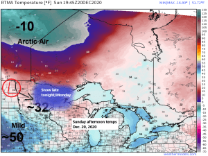
An Alberta Clipper will bring a round of snow to the Northland later this evening into Monday.
Seeing a nice temperature gradient across the area today with arctic air off to our north and very mild air to our south. Will see an area of low pressure track along this temperature gradient as it cuts through southern portions of the Northland on Monday.
- Snow develops/moves into western portions of the Northland this evening (6-9 PM)
- Snow is forecast to reach Duluth and Superior around 10 PM-Midnight tonight.
- Snow tapers off to scattered snow showers from W-E inside/near the black outlined area on map Monday morning.
- A steadier snow should continue most of the day Monday across northern Minnesota, North Shore and Arrowhead, with snow in these areas ending Monday evening.
18z NAM 3km model simulated radar forecast until Midnight Tuesday.
Source: https://weather.cod.edu/

Should be just enough snow for people who don’t like snow to complain, and those that like snow will want more than what this system will bring to the area.
For Duluth and Superior: I’m forecasting 2 to 3 inches of snow from late this evening through Monday afternoon. Computer models are in good agreement, and 18/20 GEFS members show the Twin Ports getting at least 2″ of snow out of this event, in other words 90% of the members show at least 2″ of snow, while just 10% show <2″ of snow in the Twin Ports.

Water vapor loop from Sunday, December 20, 2020 (loop time 9:40 AM to 1:30 PM CT)
Source: https://www.star.nesdis.noaa.gov/

A mild start to the week in Duluth, followed by a brief plunge of arctic air just in time for the Christmas holiday, but after that temps moderate a bit and get back closer to normal as we head toward the end of the month.
Source: https://weathermodels.com/

Some more snow is possible in the Northland in the Tuesday-early Thursday time frame, but computer models are still struggling trying to figure out how this system will evolve, but the trend is for generally a weak system with mostly light snow in northeast Minnesota and northwest Wisconsin for the midweek time frame, however, should this system phase earlier rather than later, then we could see a more significant winter system affecting parts of the Northland around midweek (note, similar to what the GFS model had been showing up until today, but even now the GFS has trended toward a much lighter snowfall compared to prior runs over the last few days)
Source: https://www.tropicaltidbits.com/

It’s been a warm and dry December in the Northland which is what the long range forecast from the CFS model was showing for December, and up to this point that forecast has been spot on, but for people who enjoy cold and snowy weather, you always wanna see a long range forecast be wrong, especially if its calling for warm and dry conditions.
| Average Monthly Temperature and departure from normal for December 2020 (thru the 19th) Ashland, WI: 25.7 degrees; +5.5 degrees above normal Brainerd, MN: 24.8 degrees; +7.7 degrees above normal Duluth, MN: 23.4 degrees; +6.9 degrees above normal International Falls, MN: 21.3 degrees; +9.4 degrees above normal Hibbing, MN: 20.0 degrees; +6.8 degrees above normal Note: December 2020 is in the running for a top 10 warmest December on record at Ashland, Brainerd, International Falls and Hibbing. |
Total precipitation and departure from normal for December 2020 (thru the 19th)
Duluth, MN: 0.07″; -0.69″ below normal
International Falls, MN: 0.33″; -0.18″ below normal
Not a whole lot of snow so far this month – Total snowfall thru December 19th and departure from normal
Duluth, MN: 1.7″; -8.7″ below normal

Snowfall is running a little closer to normal so far this month at International Falls.
International Falls, MN: 6.1″; -3.0″ below normal

Duluth has only picked up 16% of its normal snowfall so far in December 2020, while International Falls is faring quite a bit better, with snowfall running 67% of normal so far this month.
Source: https://mrcc.illinois.edu/

Very few subzero nights so far this December
Only 1 subzero night so far this month at Duluth, Minnesota. Average in December is 9 subzero nights. Most is 23 set in 2013.
3 subzero nights so far this month at International Falls, Minnesota. Average in December is 14 subzero nights. Most is 27 set in 1924.
A dry 2020 in the Twin Ports
2020 has been a very dry year in Duluth, with only 20.34″ of precipitation thru December 19. Normal precip to date is 30.51″, we’re -10.17″ below normal for the year.
2020 could end up as a top 10 driest year on record in Duluth unless we get an additional 1.01″ of precipitation by the end of this month which would drop 2020 out of the top 10 driest years on record list. Will see what happens.
Source: https://w2.weather.gov/

Tim
Leave a Reply