A widespread 1 to 5 inch snowfall across northeast Minnesota and northwest Wisconsin last night and this morning. For Duluth last night’s snow event was the biggest one we’ve seen in over a month, or since November 15 when 5.2″ of snow fell.
December snowfall total at the Duluth Airport is up to 5.2″ after last night’s snow event. We’re still -6.3″ below normal for the month.
Seasonal snowfall in Duluth continues to run above normal, however, with 36.4″ of snow so far this season, this is +8.8″ above normal to date.
-A break from the snow tonight and Tuesday, but there could be a band of snow or a wintry mix that develops late Tuesday afternoon/Tuesday evening while it lifts quickly N-NE through northern Minnesota (black outlined area on animation below)
21z RAP model simulated radar forecast valid 9 AM Tuesday to Midnight Wednesday.
Source: https://weather.cod.edu/

-Warm/humid air pumping north into the upper Midwest could lead to areas of fog and mist across parts of the Northland Tuesday night into Wednesday morning, with patchy freezing drizzle also possible during that time.
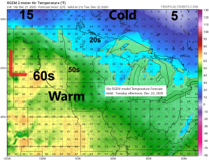
-Arctic air over the Northern Plains Wednesday morning spreads east into the Northland Wednesday afternoon-Wednesday evening with some accumulating snow also expected along with gusty north to northwest winds.
-Uncertainties continue today on the storm track and how the trough sets up per model data for midweek, but there is at least a little bit of potential for the midweek system to turn into a more significant winter storm in parts of northeast/east-central Minnesota and northwest Wisconsin. Note: The German-Icon and RGEM models as well as a few of the GFS model runs have been showing a more impactful snow event, but then you have the NAM model which keeps the system progressive while keeping the area of low pressure passing north of our area which really limits how much snow falls in our area on Wednesday.
-Temps Wednesday morning could be in 30s to lower 40s across east-central Minnesota and northwest Wisconsin, but then fall into the single digits by Wednesday evening. Could be looking at a risk for a flash-freeze in some parts of our area late Wednesday afternoon.
Source: https://weathermodels.com/

Snowfall Reports from around the Northland from Sunday night and Monday, December 20-21, 2020
Source: https://www.weather.gov/dlh/
- 3 E Payne, MN: 5.3″
- Cotton, MN: 5.0″
- 1 WSW Two Harbors, MN: 5.0″
- Wolf Ridge, MN: 4.5″
- 4.1 NNE Duluth, MN: 4.4″
- Rice Lake, MN: 3.6″
- 1 W Silver Bay, MN: 3.5″
- Duluth Airport: 3.5″
- 1 SSW Duluth, MN: 3.1″
- 3 W Cloquet, MN: 3.0″
- 5 NNW South Range, WI: 3.0″
- 1 ENE Duluth, MN: 3.0″
- Two Harbors, MN: 3.0″
- 12 N Grand Rapids, MN: 3.0″
- 3 N Mahtowa, MN: 2.4″
- 1.2 W Solon Springs, WI: 2.4″
- Wrenshall, MN: 2.4″
- International Falls, MN: 2.3″
- 7 WSW Pine River, MN: 2.0″
- 8 NE Cook, MN: 2.0″
- Maple, WI: 2.0″
- 9.6 W Aitkin, MN: 1.5″
- Brainerd, MN: 1.1″
The next system to keep an eye on will be moving ashore into the Pacific northwest tonight, so we should see the next few model runs tonight and Tuesday come into better agreement as to how this system will evolve as it makes its way into the upper Midwest on Wednesday.
Water vapor loop from Monday, December 21, 2020 (loop time 2:30 PM to 4:20 PM CT)
Source: https://www.star.nesdis.noaa.gov/

No doubt about it the 500mb trough which swings through the Northland on Wednesday looks pretty potent on the computer models today. This system has potential to become a more significant snow maker in some parts of our area, but some of it will depend on if the trough can slow down, dig south and take on more of a negative tilt, if it can do all that, then I think that would increase the chances for a more significant snowfall in some parts of the Northland Wednesday afternoon into Thursday morning. However, should the trough remain progressive and not really take on a negative tilt until it passes east of our area, then we would mainly see a light snowfall event in most of the Northland.
The NAM model has trended toward the trough taking on a slight negative tilt late Wednesday. And as the energy moves into the Pacific northwest tonight will see if the next few runs per NAM model show a slower/deeper and more negative tilted trough compared to what the 12z and 18z runs from today are showing.
Animation below is the 500mb forecast valid 6 AM Wednesday to 6 AM Thursday.
Source: https://weather.cod.edu/

As of the 12z GEFS model run from Monday morning, there are 16/20 or 80% of its members showing some snow across the Northland on Wednesday into early Thursday, and out of those 16 members some do show quite a thump of snow impacting parts of northeast Minnesota and northwest Wisconsin.
Note: The European computer model also shows some snow across the area on Wednesday, although the greatest amounts would be across northern Wisconsin and possibly over the tip of the Minnesota Arrowhead, or north/east of Duluth.
Here’s the 20 member GEFS model snowfall forecast for the midweek system. Note: I highlighted the members that show a more significant snowfall.

Tim
Leave a Reply