12 PM Update 12.23.2020
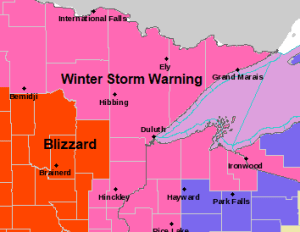
- Blizzard Warning (red area on map) has been issued for southwest portions of the Northland until Midnight tonight including the cities of Walker, Cass Lake, Brainerd, Hill City, Aitkin and McGregor
- The rest of northeast Minnesota and most of northwest Wisconsin remain under a Winter Storm Warning, except for the Hayward and Winter areas in northwest Wisconsin where a Winter Weather Advisory is in effect.
- High winds could lead to sporadic power outages across parts of the Northland through late tonight.
Note: There is a chance that we see the winter storm warning upgraded to a blizzard warning for a time late this afternoon-this evening a little farther east in the Northland to include the I-35 corridor from Duluth to Hinckley.

- Expect rapidly falling temperatures in Duluth and Superior over the next few hours as temperatures drop from the low and mid 30s as on Noon today, down to around 20 by 2 PM, and to the single digits by 6 PM.
- North to northwest winds will continue to increase in the Twin Ports this afternoon with gusts of 30 to 45 mph, to possibly as strong as 50 mph through late this evening.
- Blowing and drifting snow will develop in the Twin Ports by later today as snow accumulates. Expect times of whiteout to near whiteout conditions by late this afternoon and into this evening.
Source: https://lab.weathermodels.com/

Travel is not advised due to white out conditions in the purple areas on image below per MNDOT.
Pink areas indicate completely covered roads.
Source: https://511mn.org/

Deep low pressure ~989mb was located along the northeast Iowa/southeast Minnesota state line as of Noon today. This low will deepen a bit more as it lifts NE through tonight (storm track in yellow on map below)

Look at how the precipitation has filled in across the area over the last few hours. Also of note is the precipitation blossoming down toward Minneapolis, this would be the main part or the teeth of this winter storm, and expect that area of precip to continue to lift N-NE this afternoon.
Note: Radar loop from 5:14 AM to 12:05 PM CT, Wednesday, December 23, 2020.
Source: https://weather.cod.edu/

Water vapor loop from 9:01 AM to 12:11 PM CT, Wednesday, December 23, 2020.
A classic looking winter storm!
Source: https://weather.cod.edu/

Based on the 12z model run from Wednesday morning I don’t see any reason to alter my snowfall forecast for this storm at the moment.
I still think there is a chance that we end up with 8 to 12 inches of snow in Duluth and Superior by early Thursday morning.

Note: I’ll have more updates on this storm through the afternoon and evening, thanks for reading!
Tim
Leave a Reply