Still looks like a widespread 2 to 4 inch snowfall across the Northland tonight into Wednesday morning. Note: Isolated 5 inch totals are possible anywhere in the 2-4″ zones, but I don’t think the 5″ totals will be very common in our area.

Roads are completely (pink areas) or partially (blue areas) covered with snow in west-central and southern Minnesota as of 3:55 PM Tuesday, and these conditions will spread further northeast through the evening. Plan on a slippery Wednesday morning commute across the Northland.
Source: https://511mn.org/ (Minnesota Road Conditions); https://511wi.gov/ (Wisconsin Road Conditions)

Snow (blue colors on animation below) will continue to overspread the Northland from SW-NE this evening with snow ending from W-E from early to mid-morning Wednesday.
Note: Snow is expected to begin in Duluth and Superior around 6-7 PM tonight, and will taper off to light snow and flurries around 4 AM Wednesday.
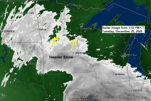
20z HRRR model simulated radar forecast ending 8 AM Wednesday.
Source: https://weather.cod.edu/

Local View – Winter Weather Advisory covers most of the Northland through Wednesday morning (purple area on map)
Source: https://www.weather.gov/dlh/

Regional View – A Winter Weather Advisory remains in effect for the purple areas on the map, while a Winter Storm Warning is in effect for the pink areas on the map.

It’s a slow process to moisten up the atmosphere when you have an arctic air mass in place, but this really isn’t unusual at all, but with broad southerly winds occurring on the backside of high pressure over Ohio and out ahead of a broad area of low pressure approaching from the west, this will continue to advect deeper moisture northward into our area tonight.

The real rich moisture currently over the Central Plains (greens on map) won’t make it this far north, instead will just get a little moisture which continues to push NE out of eastern South Dakota and southwest Minnesota this afternoon.

There is another storm for late this week, but the storm track remains too far SE of our area to give us any trouble. You can thank the split flow on keeping this late week storm to our SE as energy in the northern stream heads east just in time which helps deflect the strong system lifting N-NE out of Texas.
18z NAM model 500mb forecast shown below (6 PM Thursday to 6 PM Friday)
Source: https://weather.cod.edu/

A generally mild temperature forecast for Duluth through late next week. No subzero temps in this 10 day forecast which takes us to January 8, now if skies are clear and winds are light, we could get close to 0 or perhaps slightly below 0 Thursday morning and again Friday morning, but those look like the only days where we could get close to or a little below zero in Duluth.
Source: https://weathermodels.com/

| Low Temperature Reports from Tuesday morning, December 29, 2020 Source: https://www.weather.gov/dlh/ Hibbing, MN: -25 F Eveleth-Virginia Airport: -25 F Ely, MN: -24 F Cotton, MN: -24 F Hill City, MN: -20 F Solon Springs, WI: -20 F Minong, WI: -20 F 2 ENE Oliver, WI: -20 F South Range, WI: -19 F Moose Lake, MN: -19 F Clam Lake, WI: -18 F Danbury, WI: -18 F Hinckley, MN: -18 F Bigfork, MN: -18 F Longville, MN: -18 F Aitkin, MN: -17 F Cook, MN: -17 F Hayward, WI: -17 F Saginaw, MN: -17 F Brainerd, MN: -16 F International Falls, MN: -16 F Grand Rapids, MN: -15 F Pine River, MN: -15 F Superior Airport: -15 F Two Harbors, MN: -15 F Grand Marais, MN: -13 F Hermantown, MN: -12 F Ashland, WI: -12 F Duluth Airport: -10 F Duluth Sky Harbor Airport: -6 F Note: So far this month we’ve had 5 subzero nights in Duluth, average is 9 subzero nights in December. Last December had 8 subzero nights. |
Tim
Leave a Reply