- A widespread 1 to 4 inches of snow is expected across northeast Minnesota and northwest Wisconsin from Tuesday afternoon into Wednesday morning.
- Snow gets going in Duluth and Superior between 4 PM-7 PM Tuesday, and ends Wednesday morning around 6-9 AM.
- Temperatures look cold enough throughout the atmosphere for all snow and no mixed precipitation with this event. Also, this should be more of a powdery type of snow, and not the wet/slushy crap.
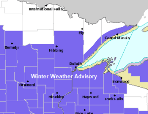
Winter Weather Advisories (purple) and Winter Storm Warnings (pink) are in effect on Tuesday as a low pressure system brings widespread accumulating snow to the Plains and Upper Midwest on Tuesday, with a mix of snow and even some ice further south across parts of Iowa, Wisconsin and Illinois.

Here’s my snowfall forecast for Tuesday afternoon through Wednesday morning. Note: It’s possible we could see an isolated 5″ total across southern portions of the Northland, but the overall quick movement of this system should keep amounts mostly in the 1-4″ range.

Generally limited to minor impacts expected in the Northland with the snow event late Tuesday into early Wednesday.
Source: https://www.wpc.ncep.noaa.gov/

A cold, dry arctic air mass will remain over the Northland tonight and Tuesday morning, but as low pressure lifts farther northeast this will begin to open up the moisture tap which is streaming north out of the Southern Plains today, but we won’t get the rich moisture as that gets shunted off to our south/east Tuesday, instead will just get a glancing blow sending our PWATS from <0.10″ Tuesday morning up to around 0.25 to 0.40″ by late Tuesday afternoon.

The amount of vertical lift in the atmosphere doesn’t look particularly strong across the Northland late Tuesday into early Wednesday, but there will certainly be enough lift to produce snow, but snowfall intensity shouldn’t be very heavy with generally weak to moderate lift passing over the area from SW-NE.
18z NAM model 700mb forecast shown below (6 AM Tuesday to 6 AM Wednesday.
Source: https://weather.cod.edu/

A busy week ahead!
The system for Tuesday and Wednesday won’t be reaching its full potential as it doesn’t phase at all as the northern low remains separate from the southern low coming out of the Southern Rockies.
System for late this week looks pretty strong at the moment and could take on a negative tilt, but the storm track remains too far SE of the Northland to produce any impacts in our area on Friday, but this system could bring a quick round of heavy snow to parts of the Midwest, possibly as far north as southern/eastern Wisconsin on Friday.

Snow arrival times on Tuesday per 12z European computer model
Source: https://weathermodels.com/
Tuesday morning looks dry across northeast Minnesota and northwest Wisconsin.

Snow spreads N-NE into western/southern portions of the Northland Tuesday afternoon-early evening from around 12 PM to 6 PM.

Snow lifts farther N/NE and is forecast to encompass the entire Northland by mid to late Tuesday evening.

Some snow lingers in the Northland overnight/early Wednesday morning.

Snow should be wrapping up from W-E Wednesday morning, with all the snow gone by Wednesday afternoon the way it looks now.

Tim
Leave a Reply