- A reinforcing shot of cold air moves in on Monday behind a cold front which moves through the Northland tonight.
- Subzero temps possible across northern Minnesota Monday morning, and near zero to below zero temps area-wide for Monday night. Note: Temps Monday afternoon will range from the single digits below to lower teens above zero across the Northland.
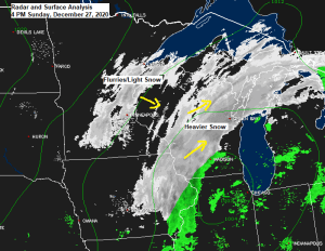
- Lingering areas of light snow and flurries will come to an end this evening.
- Our next shot for snow comes late Tuesday spreading from SW to NE across the Northland. Most of the snow falls Tuesday night, and then tapers off Wednesday morning the way it looks now.
Today’s system didn’t phase at all, as one piece of energy continues to dive SE out of North Dakota while a more organized system heads ENE out of Iowa.
Water vapor loop from Sunday, December 27, 2020 (loop time 2:06 PM to 4:01 PM CT)
Source: https://www.star.nesdis.noaa.gov/

Here’s a look at the system which is forecast to bring at least a bit of snow to the Northland from late Tuesday into Wednesday (black circled area on animation below)
Loop time 2:16 PM to 4:11 PM CT, Sunday, December 27, 2020.

The system moving ashore into California over the next 12-18 hours is forecast to split into two, with one piece of energy moving NE out of the Rockies Tuesday and Wednesday, while a stronger piece of energy digs SE into the Southern Plains around midweek, and then will see that feature lift NE toward the Southern/Eastern Great Lakes region late this week.

Here’s what I have for snowfall amounts for the midweek event.
2-4″ for east-central Minnesota and all of northwest Wisconsin including for Duluth and Superior, and generally 1-2″ across the north. Note: Amounts/gradients could change/shift a bit over the next 24 hours.
This snow event looks to be driven mostly by warm air advection as a broad southerly flow develops east of an approaching trough and area of low pressure. At the moment it looks like this system will remain progressive enough which should help keep snow amounts <6″ in our area, in fact I think it might be difficult to even get more than 3-4″ out of this system, but will see.
…Timing of when the snow begins on Tuesday…
3 to 6 PM along a Bigfork to Siren line.
6-9 PM for the Iron Range, most of the North Shore and all of northwest Wisconsin.
After 9 PM along the Borderland and Arrowhead.
Note: Snow is forecast to reach Duluth and Superior around 6-9 PM on Tuesday the way it looks now.

Tim
Leave a Reply