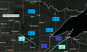
- A minor snow event is still likely on Sunday, although this one has trended a lot weaker for our area, not that it ever looked very big to begin with, but I’m really not expecting much more than a skiff of snow in most of the Northland on Sunday, with the possible exceptions being around the Brainerd Lakes, and also across southeast portions of northwest Wisconsin where snow totals could reach 1 or 2 inches. Note: A trace to an inch of snow is possible in Duluth and Superior Sunday.
- Some more snow is looking likely sometime in the late Tuesday to Wednesday time frame, but this one has also trended toward lower QPF/snowfall totals for the Northland.
- Could things change with the midweek system? They certainly could based on what I’ve been seeing in these model forecasts with anything past about 2 days, don’t trust any of them, but at the moment the models are trending toward less snow in northeast Minnesota and northwest Wisconsin during the Tuesday-Wednesday time frame.
The computer models continue to struggle big time with this split flow weather pattern. These models in the long range don’t have a clue when it comes to how much or how little phasing will occur between systems in the northern branch and southern branch of the jet stream, do they phase fully, partially, or just slightly, or not at all, this in turn affects how much or how little snow we get in our area. Storm tracks and how quickly these systems move through also play a big role on snow totals, but so far this season it seems these systems have been very progressive, they move in and move out quickly. Bottom line is what looked like a very snowy week ahead in the Northland has changed significantly, yes it still looks like will get some snow this week, but not nearly as much as what some of the models (Euro) earlier in the week were showing in the week ahead.
Temperatures don’t look too bad in Duluth over the next 10 days, with only one subzero temperature in the forecast! Note: Normal high is right around 20 degrees, normal low around 5 degrees in late December.
Source: https://weathermodels.com/

Here comes the energy which will support our next snow event as it heads SE out of Saskatchewan and Manitoba and through the upper Midwest on Sunday.

Here’s a look at the simulated radar forecast valid from Midnight tonight to Midnight tomorrow night per 18z NAM 3km model.
Source: https://weather.cod.edu/

Areas in dark blue on the map below could pick up 6″ or more of snow with the midweek system, while farther north snow amounts could range from 0.1 to 11″ (kidding) more likely in the 1-4″ range. Again though I would expect some changes to this forecast over the next few days.

Tim
Leave a Reply