- Cold temperatures continue tonight with lows in the single digits, teens and 20s below zero across the Northland.
- Christmas Day will feature strong warm air advection causing temps to climb into the teens to lower 20s Friday afternoon (near normal for late December)
Updated snowfall stats for Duluth, Minnesota after Wednesday’s storm
- 10.7″ of snow so far this month; -2.6″ below normal.
- 41.9″ of snow so far this season; +12.5″ above normal.
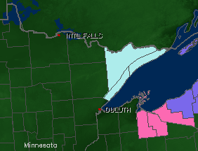
Wind Chill Advisory (light blue area on map) in effect until 6 AM Friday for the North Shore and Arrowhead including the cities of Two Harbors, Finland, Silver Bay, Lutsen, Grand Marais and Hovland. Wind chills as low as 30 below zero are expected in the advisory area tonight.
Winter Storm Warning (pink area on map) remains in effect until Midnight tonight for portions of the South Shore including the cities of Ashland, Butternut, Gile and Hurley. Additional snow accumulations of 1 to 3 inches are expected in the warned area tonight.
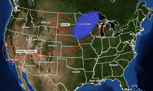
Who’s ready for some Greenland blocking? A very interesting weather pattern setting up for the next 2 weeks with a potential for multiple low pressure systems to track east out of the Rockies.
Here’s the 12z Euro ensemble model 500mb forecast valid thru January 8, 2021.
Source: https://weathermodels.com/

Two systems I’m keeping an eye on. The first one drops SE out of Manitoba on Sunday (yellow outlined area on map)
Model images from the 12z Euro model run.
Source: https://www.tropicaltidbits.com/

And the second system is forecast to move ashore into California on Monday (yellow outlined area on map) Will need to keep an eye on the track of this one as computer models have it lifting far enough north where it could impact northeast Minnesota and northwest Wisconsin bringing some more snow (possibly a significant amount) to parts of the area around the middle of next week, or from ~December 29 to December 31.

The system on Sunday could bring a widespread 1 to 2 inch snowfall to most of northeast Minnesota and northwest Wisconsin the way it looks now, but some changes are certainly possible over the next day or two.

Tim
Leave a Reply