- Temperatures will remain on the mild side tonight into Thursday morning, but this won’t last as colder air moves in by Thursday afternoon ahead of what looks to be a long duration of arctic air from Friday through much of next week.
- Before the arctic air arrives we have some wintry precipitation to deal with for tonight and Thursday. A mix of snow, freezing drizzle and possibly some sleet is expected tonight with a transition to all snow on Thursday.
- Dangerously cold wind chills are likely beginning on Friday and continuing through at least early next week (possibly beyond) wind chill advisories and warnings will likely be needed across the entire Northland starting Friday or Saturday and until further notice.
Here’s my updated snowfall forecast for our next event.
- Highest totals in far eastern parts of northwest Wisconsin (5-7″)
- 2-5″ of snow in the Arrowhead of Minnesota and for most of northwest Wisconsin
- 1-2″ of snow across most of northern Minnesota including for Duluth and Superior.
- An inch or less of snow from Brainerd and Aitkin to Grand Rapids and Hibbing, and south to the Moose Lake and Hinckley areas.
Note: There is still a chance that snow totals may end up slightly higher in far eastern Minnesota and in the Duluth area on Thursday, instead of 1-2″ we could be more in the 2-4″ range, but those chances remain on the low side as of late this afternoon, but a few of the computer models continue to show slightly higher snow amounts extending farther west into eastern Minnesota.

We’ve got some wintry precipitation ahead for tonight and Thursday as a complex low pressure system makes its way through the region, however, this likely won’t be a major snow or ice event in northeast Minnesota and northwest Wisconsin since this system won’t really become fully phased (more organized/stronger) until it’s east of our area on Thursday into early Friday.
Winter weather headlines cover a large portion of the region through early Friday.
Blizzard Warning (red)
Winter Storm Warning (pink)
Winter Weather Advisory (purple)
In the Northland: There is a Winter Weather Advisory in effect for all of northwest Wisconsin and the Arrowhead of Minnesota from Midnight tonight to 6 AM Friday including the cities of Grand Marais, Isabella, Superior, Solon Springs, Minong, Grantsburg, Siren, Shell Lake, Bayfield, Washburn, Ashland, Hayward, Winter, Hurley, Gile and Upson. Accumulating snow along with a light glaze of ice is likely in the advisory area. Plan on slippery road conditions. Travel could be difficult, and the hazardous conditions could impact the Thursday commutes, and the Friday morning commute.

NOAA’s Winter Storm Severity Index valid thru Friday shows that most of the major impacts from this next system will remain east of the Northland, with generally limited impacts forecast for northeast Minnesota (light blue) while parts of northwest Wisconsin could have minor impacts (yellow) Note: A more impactful system is expected farther east where Moderate impacts are possible (orange)
Source: https://www.wpc.ncep.noaa.gov/

- Areas of snow or a wintry mix of precipitation including sleet and freezing drizzle will develop or move into the Northland this evening and overnight, with a light glaze of icing possible in some parts of the area.
- Some snow is likely in all of the Northland on Thursday, with northwest Wisconsin and Arrowhead of Minnesota likely seeing the longest duration of snow, with a lesser chance in far eastern Minnesota.
- Snow could linger into Thursday night/Friday morning in the Arrowhead of Minnesota and along the South Shore in northwest Wisconsin due to lake effect (NW wind)
Simulated radar forecast valid thru 6 AM Friday per 18z RGEM model.
Source: https://www.pivotalweather.com/

Areas of freezing drizzle/freezing rain are possible over parts of the Northland tonight with ice accumulations of a trace to around 0.05″ possible.
Source: https://weathermodels.com/

The two lows over the Midwest this afternoon (each marked by a red L on the image below) will eventually phase into one main low pressure center once this system reaches the central/eastern Great Lakes region later Thursday, and once that happens pressures will fall, with a rather deep surface low developing by Friday morning of around 980-985mb

Upper level ridging which was over the Northland today will be replaced by an upper level trough which will move east out of the Rockies tonight. This trough will become increasingly negatively tilted on Thursday as it moves into the Great Lakes.

Highs today were in the mid 20s to mid 30s in the Northland, and these kinds of temperatures won’t be returning anytime soon.
Source: https://lab.weathermodels.com/

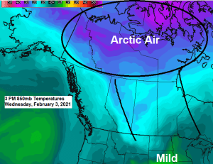
Will tap into the arctic pipeline starting Thursday night, and once that happens it won’t be going anywhere for at least a week the way it looks now. 850mb temperatures in this arctic air mass will likely range from around -25 to -32C in the Northland starting Friday and continuing through most of next week.

Thursday starts mild, but temperatures will start to fall by the afternoon.
Coldest stretch looks to be this weekend into early next week with daytime highs not getting above zero.
Looks like we might warm up a bit for the middle/end of next week, at least with our daytime highs which may climb back up above zero, although subzero lows are still expected.
Here’s the 10-day temperature forecast for Duluth.
Source: https://weathermodels.com/

Tim
Leave a Reply