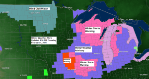
-Winter Storm Warning is in effect until 6 PM Friday along the South Shore in northwest Wisconsin including the cities of Washburn, Bayfield, Ashland, Hurley, Gile and Upson. And until 6 AM Friday including the cities of Hayward and Winter in northwest Wisconsin.
-Winter Weather Advisory is in effect until 6 AM Friday including the cities of Isabella, Grand Marais, Solon Springs, Minong, Shell Lake and Spooner.
Note: Wind chill headlines will likely be needed across the Northland beginning Friday night or Saturday and continuing into next week, with wind chills of -20 to -45 degrees likely this weekend into at least early next week.
Not expecting much more snow tonight except in the tip of the Minnesota Arrowhead, and eastern parts of northwest Wisconsin where another 1 to as much as 3 inches of snow could fall by daybreak. The rest of us could see a few flurries at times tonight and Friday.

Any chance of a snowier pattern developing in the Northland is pretty much gone at least thru mid month thanks to the arctic air setting up more over the upper Midwest vs. farther to the west. So the dry weather pattern looks to continue in our area at least for the next 2 weeks.
That’s one snow-less 15-day forecast for Duluth from today’s European ensemble model. We average 12.4″ of snow in February in Duluth so will see if the back half of this month turns more active or not, because the first half of this month looks pretty dry.
Source: https://weathermodels.com/

A cold 10 day forecast for Duluth, with possibly a 4 day stretch of subzero temps. We might get back up above zero for daytime highs the middle/end of next week, but overnight lows will still be well below zero.
Should also be noted that there is some uncertainty in the models regarding how long the real cold air sticks around for.
Normal highs in early February in Duluth are in the lower 20s with normal lows in the single digits. Temperatures through next week will be well below normal for this time of year, but it has been a lot colder around here in the past compared to what will see over the next week.
Source: https://weathermodels.com/

- Lowest temperature so far this winter at Duluth is -14 F on January 28. This upcoming stretch of cold weather should produce temperatures colder than -14 in Duluth.
- Only 12 days with a subzero temperature so far this winter in Duluth. Normal for the winter (Dec-Feb) is 35 subzero days.
How often do -20 F or colder temperatures occur in Duluth? On average, we typically have 6 days during the winter where the temperature dips to -20 F or colder in the city, we’ve had none so far this winter, and last winter had only 1 day where the temperature was -20 F or colder in Duluth.
A strong cold front continues to move east this afternoon, although it has slowed some in response to an area of low pressure which is developing and moving more or less up along the frontal boundary.
Note: The high temperature in Duluth was 31 degrees which occurred at 1:10 AM today, temperatures have fallen this afternoon, and at 4 PM today the temperature was 18 degrees, and this is still actually pretty warm considering how cold it’ll be over the next several days.

The door is open for arctic air to spill south/east the next few days. Widespread temperatures in the teens, 20s and 30s below zero this afternoon across western/northern Canada, with even a few locations still in the -40s this afternoon.

Low pressure centered over south-central Wisconsin late this afternoon will deepen to around 984mb as it lifts NE, reaching eastern Lake Superior by daybreak. Most of the snow associated with this system will remain mainly east of the Northland tonight.

Here’s a look at today’s system as it deepens while lifting NE into the Great Lakes region per Goes-16 infrared satellite imagery – Loop time 4:36 AM to 5:01 PM, Thursday, February 4, 2021.
Note: Heavier precipitation near/under the brighter/colder cloud tops.
Source: https://www.star.nesdis.noaa.gov/

Snowfall Reports from around the Northland for February 4, 2021
Source: https://www.weather.gov/dlh/
- 2 W Hayward, WI: 6.5″
- 2 NW Delta, WI: 5.5″
- 4 W Grand Marais, MN: 4.8″
- Sarona, WI: 4.5″
- 1 WSW Washburn, WI: 4.0″
- Butternut, WI: 4.0″
- 1 SSE Oulu, WI: 3.5″
- Spooner, WI: 3.5″
- Hertel, WI: 3.5″
- Duluth Airport: 3.1″
- 4 SSE Webster, WI: 3.0″
- Mellen, WI: 3.0″
- 4 E Sturgeon Lake, MN: 3.0″
- 6 N Knife River, MN: 3.0″
- Gile, WI: 2.5″
- 3 N Amnicon Falls S.P: 2.3″
- 3 NE Duluth, MN: 2.1″
- 3 E Payne, MN: 2.0″
- 1 S Moose Lake, MN: 1.9″
- 3 N Mahtowa, MN: 1.8″
- International Falls, MN: 1.1″
Tim
Leave a Reply