The cold air is here and it won’t be going anywhere until further notice. Wind Chill headlines are in effect across the entire Northland through the weekend, and into early next week across northern and eastern Minnesota.
- Low temperatures across the Northland will be in the single digits below to around 20 below tonight, and in the teens, 20s and 30s below zero Saturday night through Monday night, with 40s below possible in the traditional cold spots Saturday night and again Sunday night.
- Last time Duluth saw a -20 F or colder temperature was on February 13, 2020 (low of -21 F)
- Daytime highs will range from around zero to 10 below in northeast Minnesota and northwest Wisconsin for Saturday, Sunday and Monday.
It’s a step down process. Today was colder than yesterday, and this weekend will be even colder than today as arctic air continues to flood SE out of western and central Canada.
Speaking of today’s temperatures, they actually weren’t too bad in northeast Minnesota and northwest Wisconsin as temperatures ‘warmed’ into the single digits to around 10 above, but that wind has been nasty, and unfortunately the wind won’t be diminishing a whole lot through the weekend.

It’s so cold to our north that satellite is thinking it’s cloudy, when it really isn’t. Also seeing reports of ice crystals across parts of Canada today.

Here’s a loop of the above image, notice how the blue and green colors near the white arrow on map don’t really move, that’s just the arctic air being picked up on infrared satellite imagery, pretty cool! Meanwhile to our east there is an upper level ridge east of Hudson Bay Canada (blue H) and low pressure over eastern Ontario (red L) those two things are helping to pull down cold/arctic air from northern Canada.
Source: https://weather.cod.edu/

-Wind Chill Advisory in effect from Midnight tonight to Noon Sunday including the cities of Pine City, Hinckley, Superior, Washburn, Bayfield, Ashland, Hurley, Grantsburg, Spooner and Hayward. Wind chills from 25 below to 35 below zero. The dangerously cold wind chills could cause frostbite on exposed skin in as little as 10 minutes.
-Wind Chill Advisory in effect from 6 PM this evening to 8 PM Saturday and a Wind Chill Watch in effect from Saturday evening through Tuesday morning including the cities of International Falls, Bigfork, Grand Rapids, Ely, Hibbing, Two Harbors, Isabella, Silver Bay and Grand Marais. Wind chills of 30 below to 40 below zero tonight and Saturday, and as low as 45 below zero Saturday evening through Tuesday morning. The dangerously cold wind chills could cause frostbite on exposed skin in as little as 10 minutes.
-Wind Chill Advisory in effect from 6 PM this evening until Noon Tuesday including the cities of Walker, Pine River, Brainerd, Hill City, Aitkin, Moose Lake, Cloquet and Duluth. Wind chills of 25 below to 40 below zero. The dangerously cold wind chills could cause frostbite on exposed skin in as little as 10 minutes.

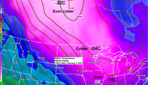
Wind chill forecast thru 6 AM Monday, February 8, 2021.
12z European model.
Source: https://www.pivotalweather.com/

850mb winds look strongest tonight into Saturday morning (30-45 knots) and then will see them diminish a bit Saturday afternoon through Monday morning (around 20-25 knots) what this all means is will continue to tap into these stronger winds aloft which will lead to gusty winds near the surface, and even though wind speeds may come down a bit by Sunday, even a 10 mph wind is not a good thing when factoring in how cold the temperature will be.
18z NAM model 850mb wind forecast thru 6 AM Monday, February 8, 2021.
Source: https://www.pivotalweather.com/

It’s a dry pattern for the Northland with no snow events expected through at least the middle of next week, here’s a check on snowfall totals for the winter of 2020-2021 (thru February 4)
Duluth, MN: 28.7″ (normal 38.9″) -10.2″ below normal
International Falls, MN: 27.4″ (normal 31.5″) -4.1″ below normal
Source: https://mrcc.illinois.edu/CLIMATE/

International Falls has had 87% of its normal snowfall this winter (thru February 4) while Duluth has had 74% of its normal snowfall so far this winter.

Seasonal snowfall totals have varied quite a bit across the area, with Duluth still running above normal, while International Falls is running well below normal.
Note: Totals below are thru February 4
Duluth, MN: 59.9″ (normal 55.0″) +4.9″ above normal
International Falls, MN: 36.5″ (normal 47.5″) -11.0″ below normal

Duluth has had 109% of its normal snowfall so far this season, while International Falls has had 77% of its normal snowfall so far this season.

Tim
Leave a Reply