Daytime highs will generally range from around 10 below to 5 above zero in northeast Minnesota and northwest Wisconsin on Monday, Tuesday and Wednesday while overnight lows will be in the teens, 20s and 30s below zero.
No widespread snows in our area this week, although there could be a few flurries at times, but that would be about it. Models diverge significantly starting later this week with the Canadian and Euro models going with a much snowier pattern in our area while the GFS model remains very dry.
- Low of -24 F at the Duluth Airport on Sunday, February 7, 2021, this is the first -20 or colder temperature in Duluth since February 13, 2020, and this morning’s low of -24 degrees is the coldest temperature in Duluth since January 31, 2019 when the low reached -31 F.
- No new record lows reported in the Northland Sunday morning (February 7, 2021) and it doesn’t look like will set any new record cold high temps for February 7 either, although all 5 climate stations in the Northland (Duluth, International Falls, Hibbing, Brainerd and Ashland) look to have a top 5 coldest high temperature on record today (February 7, 2021)
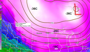
Widespread frigid temperatures across Alaska, Canada and into northern parts of the US today, pretty incredible how large of an area has subzero temperatures this afternoon.

-Wind Chill Warning in effect until Noon Tuesday including the cities of International Falls, Bigfork, Grand Rapids, Hibbing, Ely, Two Harbors, Isabella, Silver Bay and Grand Marais. Wind chills as low as 45 below zero.
-Wind Chill Advisory in effect until Noon Tuesday including the cities of Walker, Hill City, Duluth, Pine River, Brainerd, Aitkin, Superior, Washburn, Bayfield, Ashland and Hurley. Wind chills as low as 35 below to 40 below zero.
-Wind Chill Advisory in effect until 10 AM Monday including the cities of Pine City, Hinckley, Grantsburg, Spooner and Hayward. Wind chills as low as 30 below zero.
Note: The dangerously cold wind chills could cause frostbite on exposed skin in as little as 10 minutes.

The Great Lakes are acting as a heat/moisture source again today, and with a ton of arctic air moving over the still relatively ice-free lakes, we’re seeing widespread lake clouds and snow showers today for west or west-northwest favored snowbelts. Also of note are some mid/high level clouds streaming east out of western/southern Minnesota this afternoon (yellow outlined area on map) Should these clouds pass over and then linger in the Northland this may help keep temps ‘slightly’ warmer tonight compared to what we saw Sunday morning, but either way you slice it, another bitterly cold night is ahead, and even more likely if skies remain generally clear tonight.
Goes-16 visible satellite loop from Sunday, February 7, 2021.
Source: https://weather.cod.edu/

***Record Low Temperatures for February 8***
Note: Hibbing has the greatest chance at getting close to or possibly breaking their record low for February 8, the other records on the list below should be safe.
International Falls, MN: -48 F set in 1909
Brainerd, MN: -41 F set in 1933
Ashland, WI: -38 F set in 1934
Duluth, MN: -31 F set in 1933
Hibbing, MN: -30 F set in 1988
Low Temperature reports from Sunday morning, February 7, 2021
Source: https://www.weather.gov/dlh/
- Cotton, MN: -35 F
- 3 SW Butternut, WI: -35 F
- Babbitt, MN: -30 F
- International Falls, MN: -29 F
- Northome, MN: -29 F
- Orr, MN: -29 F
- Barnes, WI: -28 F
- Deer River, MN: -28 F
- Effie, MN: -28 F
- Cook, MN: -27 F
- Crane Lake, MN: -27 F
- Danbury, WI: -27 F
- Chisholm-Hibbing Airport: -26 F
- Cloquet, MN: -26 F
- Grand Marais Airport: -26 F
- Grand Rapids, MN: -26 F
- Hinckley, MN: -26 F
- Minong, WI: -26 F
- Saginaw, MN: -26 F
- Twig, MN: -25 F
- Duluth Airport: -24 F
- Glidden, WI: -24 F
- McGregor, MN: -24 F
- Hayward, WI: -22 F
- Walker, MN: -22 F
- Esko, MN: -21 F
- Duluth Harbor: -18 F
Wind Chills reports from Sunday morning, February 7, 2021
Source: https://www.weather.gov/dlh/
- 2 N French River, MN: -53 F
- Duluth Airport: -52 F
- Ash Lake, MN: -51 F
- International Falls, MN: -49 F
- Isabella, MN: -49 F
- Chisholm-Hibbing Airport: -49 F
- Ely, MN: -49 F
- Orr, MN: -49 F
- Northome, MN: -46 F
- Effie, MN: -45 F
- Cotton, MN: -44 F
- Solon Springs, WI: -43 F
- Ashland, WI: -43 F
- Crane Lake, MN: -43 F
- Hinckley, MN: -41 F
- Brainerd, MN: -40 F
- Cass Lake, MN: -39 F
- Siren, WI: -39 F
- Moose Lake, MN: -35 F
- Clam Lake, WI: -34 F
- Two Harbors, MN: -34 F
- Cook, MN: -33 F
- Glidden, WI: -32 F
- Danbury, WI: -32 F
- Longville, MN: -30 F
GFS model continues to bring a lobe of the Polar Vortex (upper level low) on a southeast track into northern Minnesota and northern Wisconsin late this week/weekend (~February 12-14) however, there is quite a bit of uncertainty showing up in model guidance beginning later this week, as some models show the upper low setting up farther to the west, which then leads to slightly warmer temps for our area, and a potentially snowier weather pattern across the upper Midwest and in the Northland. Stay tuned.
12z GFS model 500mb forecast valid February 12-14, 2021.
Source: https://www.pivotalweather.com/

Tim
Leave a Reply