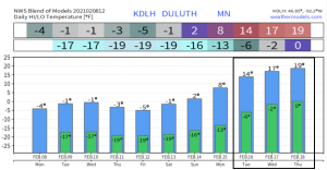
Temperatures will remain well below normal in Duluth at least thru early next week, but we may begin to climb out of this arctic air mass starting around the middle of next week or after February 15, but even that isn’t a lock since it’s so far out in model land. Note: Normals this time of year in Duluth range from the low to mid 20s for highs, and around 5 above zero for lows, so even with the possibility of milder temps around the middle of next week they still look to be below normal for this time of year.
Record Low Temperature broken at Hibbing, Minnesota this morning, Monday, February 8, 2021
New record for February 8: -34 F; old record -30 F set in 1988
- Duluth, Hibbing and International Falls recorded a low temperature which was in the top 5 coldest on record on February 7.
- A top 5 coldest high temperature on record occurred today, Monday, February 8 at International Falls and Hibbing.
Note: Doesn’t look like will break any low temperature records Tuesday morning.
…Record Lows on February 9…
- Brainerd, MN: -41 F set in 1899
- International Falls, MN: -38 F set in 2019
- Duluth, MN: -36 F set in 1899
- Hibbing, MN: -34 F set in 1975
- Ashland, WI: -32 F set in 1933 and 1951
The arctic air is locked in and shows no signs of leaving at least thru early next week. Wind chill headlines have been extended thru this weekend as will continue to have dangerously cold wind chills in place over the next several days. No surprise with the arctic air mass overhead that we likely won’t be seeing any snow around here this week, and probably into next week as well (at least thru early next week) So for now it’s all about the bitterly cold stretch of weather, and continued very dry pattern.
The widespread nature of this arctic air mass is pretty amazing!

*Wind Chill Warning* in effect until Noon Tuesday including the cities of International Falls, Bigfork, Grand Rapids, Cass Lake, Walker, Hill City, Moose Lake, Cloquet, Duluth, Hibbing, Ely, Two Harbors, Silver Bay, Isabella and Grand Marais. *Wind Chill Advisory* for these same areas in effect from Noon Tuesday to Noon Sunday. Wind Chills as low as 40 below to 45 below zero tonight into Tuesday morning, and from 35 below to 40 below zero from Tuesday afternoon through Sunday afternoon.
*Wind Chill Advisory* in effect until Noon Sunday including the cities of Pine River, Brainerd, Aitkin, Pine City, Hinckley and Superior. Wind chills as low as 35 below zero.
*Wind Chill Advisory* in effect until Noon Tuesday including the cities of Grantsburg, Spooner, Hayward, Washburn, Bayfield, Ashland and Hurley. Wind chills as low as 35 below zero.
The dangerously cold wind chills could cause frostbite on exposed skin in as little as 10 minutes.
Wind chill alerts remain active across much of the Northern Plains and upper Midwest.

Lake effect clouds/snow showers continue over Lake Superior (east of the North Shore) today, but with a westerly or a west-southwest wind continuing, most of the lake effect snow remains off-shore, except over the Keweenaw and Bayfield Peninsulas (yellow outlined areas on map) where some lake effect snow continues at times.
Also of note continues to be the lack of ice over Lake Superior, with only 6.5% of the lake covered by ice as of Monday morning, February 8, 2021 – Normal at this time of year is around 35%.

A piece of the Polar Vortex (mid/upper level low) continues to move west-southwest out of Hudson Bay and into northern Manitoba this afternoon. This upper low is forecast to start digging more to the south by late this week, and could move over the Northland sometime in the Friday-Sunday time frame.
Note: On the front side of the aforementioned upper low we could see a disturbance lift NE on Thursday bringing a period of snow to parts of the Northern Plains and upper Midwest, but at this time it looks like this snow would remain south of the Northland.
Goes-16 water vapor loop from Monday, February 8, 2021.
Source: https://weather.cod.edu/

The winter of 2020-2021 continues to run warmer than average across the region thanks to a very mild December and January, but February has started off very cold, and it looks to remain that way for a while longer, so it’s certainly possible we could see the average temps for this winter trend a lot closer to normal by the end of this month, will be interesting to see what happens over the next few weeks.
Average temps/departure from normal for the winter of 2020-2021 (thru Feb. 7, 2021)
- Duluth, MN: 17.7 F (+5.3 degrees above normal)
- International Falls, MN: 15.1 F (+8.1 degrees above normal)
- Hibbing, MN: 13.9 F (+5.0 degrees above normal)
Source: https://mrcc.illinois.edu/

Low Temperature reports from Monday morning, February 8, 2021
Source: https://www.weather.gov/dlh/
- Ash Lake, MN: -39 F
- International Falls, MN: -38 F
- Crane Lake, MN: -35 F
- Eveleth-Virginia Airport: -35 F
- Bigfork, MN: -35 F
- Cotton, MN: -35 F
- Effie, MN: -34 F
- Chisholm-Hibbing Airport: -34 F
- Longville, MN: -33 F
- Ely, MN: -32 F
- Cass Lake, MN: -31 F
- Twig, MN: -31 F
- Cook, MN: -29 F
- Moose Lake, MN: -29 F
- Deer River, MN: -28 F
- Isabella, MN: -27 F
- Hinckley, MN: -27 F
- Minong, WI: -27 F
- Cloquet, MN: -26 F
- Solon Springs, WI: -26 F
- 2 ENE Oliver, WI: -25 F
- Duluth Airport: -23 F
- Superior, WI: -18 F
- Duluth Harbor: -17 F
Wind Chill reports from Monday morning, February 8, 2021
Source: https://www.weather.gov/dlh/
- International Falls, MN: -55 F
- Crane Lake, MN: -52 F
- Margie, MN: -48 F
- Cotton, MN: -48 F
- Duluth Airport: -45 F
- Grand Marais Airport: -45 F
- Chisholm-Hibbing Airport: -43 F
- Solon Springs, WI: -41 F
- Littlefork, MN: -40 F
- Grand Rapids, MN: -39 F
- Duluth Sky Harbor Airport: -38 F
- McGregor, MN: -36 F
- Ashland, WI: -36 F
- Solon Springs, WI: -36 F
- Ely, MN: -35 F
- Washburn, WI: -35 F
- Superior Airport: -33 F
- Duluth Harbor: -32 F
Tim
Leave a Reply